Key takeaways
- A site analysis documents site constraints and surrounding context
- Orientation, topography, neighbours, streetscape, and services are the five components
- Prepare it before the design is finalised, not after
- Most councils require a drawing, not just a written report
- The site analysis is the factual basis for the SEE impact assessments
A site analysis is a document that records the physical characteristics, constraints, and context of a site before a development design is finalised. In NSW, councils require it to ensure that a proposal responds to what is actually there — the orientation, topography, neighbours, streetscape, and services — rather than being designed in isolation.
Get a council-ready Statement of Environmental Effects for your DA in 5 minutes — no town planner, no waiting.
Get your SEE report →- What a site analysis covers and why councils require it for a NSW DA
- The five components every site analysis should address
- When a site analysis drawing is required versus a written report
- How the site analysis shapes the design and the SEE
- How to use the site analysis to avoid common objections
What a Site Analysis Covers
A site analysis documents both what is on the site and what surrounds it — and getting the surrounding context right matters as much as recording the site itself, because that is what the design must respond to.
A site analysis documents both what is on the site and what surrounds it. The site itself includes its dimensions, topography, existing structures, vegetation, solar access, and constraints such as easements, flooding, or contamination. The surrounding context includes the neighbouring properties, the street pattern, the built form and heights, the visual character of the area, and any heritage items.
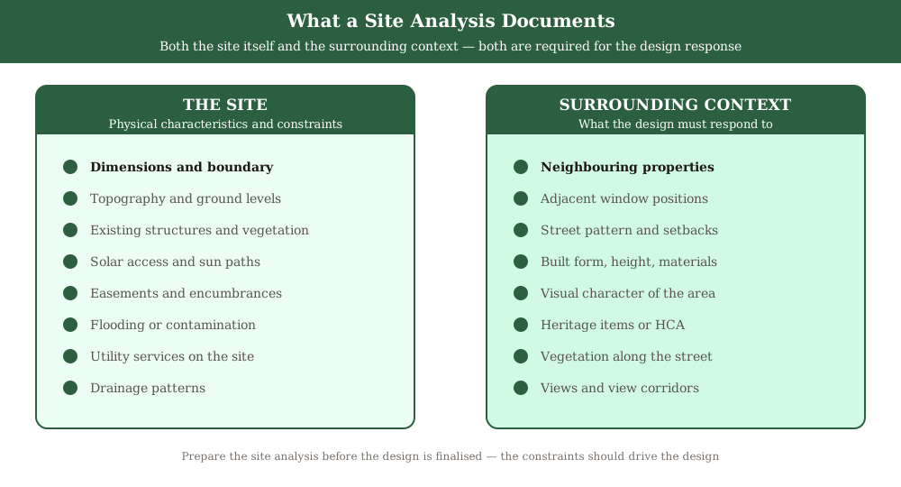
Figure 1: A site analysis documents both site constraints and surrounding context — both matter for the design response.
Councils require the site analysis because the design response to a site — the placement, height, orientation, and massing of a building — should come from understanding these factors, not precede it. A design that ignores solar access, privacy impacts on neighbours, or the dominant streetscape character is the kind of design that attracts objections and conditions.
Many councils require the site analysis to be presented as a drawing, not just a written document. The drawing shows the site in plan view with annotations identifying constraints — shadow diagrams, view lines from neighbouring windows, trees, drainage paths, utility alignments — because a drawing communicates spatial relationships in ways text cannot.
The Five Key Components of a Site Analysis
Most councils frame their requirements slightly differently, but orientation, topography, neighbouring properties, streetscape character, and utility services are the five components that appear in nearly every site analysis across NSW.
Most site analyses in NSW follow a consistent structure with five main components.
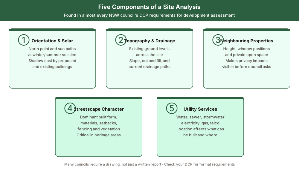
Figure 2: The five components of a site analysis for a NSW DA.
Orientation and solar access. The site analysis maps the north point, the path of the sun across the site at winter and summer solstice, the shadow cast by existing and proposed buildings, and the solar access available to the site and to neighbouring properties. This feeds directly into the passive solar design of the building and the council's assessment of overshadowing.
Topography and drainage. The analysis records existing ground levels across the site, any significant slope, cut-and-fill implications, and how stormwater currently drains. This informs basement and earthworks planning and connects directly to the stormwater management plan.
Neighbouring properties. The analysis identifies the location, height, window positions, and private open space of immediately adjacent dwellings. This is the document that makes privacy impacts visible — showing sightlines from neighbouring upper-storey windows, or the proximity of a proposed terrace to a neighbour's bedroom, before the council asks.
Streetscape character. The analysis records the dominant built form, materials, setbacks, fencing, and vegetation along the street frontage. Councils in heritage conservation areas require this component in detail. It shows whether the proposal is consistent with or at odds with the existing character — and if at odds, the design response must explain why.
Utility services. The analysis identifies utilities crossing or adjacent to the site — water, sewer, stormwater, electricity, gas, telecommunications — because their location affects what can be built where, and whether any services need to be relocated at the applicant's cost.
- Check your council's DCP for whether a drawing or written report is required
- Map orientation and solar access paths before finalising the building footprint
- Identify neighbouring window positions and private open space for privacy assessment
- Record existing and finished ground levels for stormwater and earthworks planning
- Map all utility services crossing or adjacent to the site
How the Site Analysis Feeds Into the DA
Spend 5 minutes, not 3 weeks
instantSEE generates a complete, DA-ready Statement of Environmental Effects online. No town planner. No waiting.
Get your SEE report in 5 minutes →The site analysis is the foundation document that shapes the entire DA — the SEE draws on it for impact assessments, the shadow diagrams extend it, and the stormwater plan builds on the drainage section, so a weak or missing site analysis undermines everything downstream.
The site analysis is the foundation from which the rest of the design and the rest of the DA flows. A well-prepared site analysis shapes the Statement of Environmental Effects by providing the factual basis for impact assessments. When your SEE says the building is well oriented for solar access, that the design respects the privacy of adjacent dwellings, and that the streetscape character is maintained, the site analysis is the evidence behind those statements.
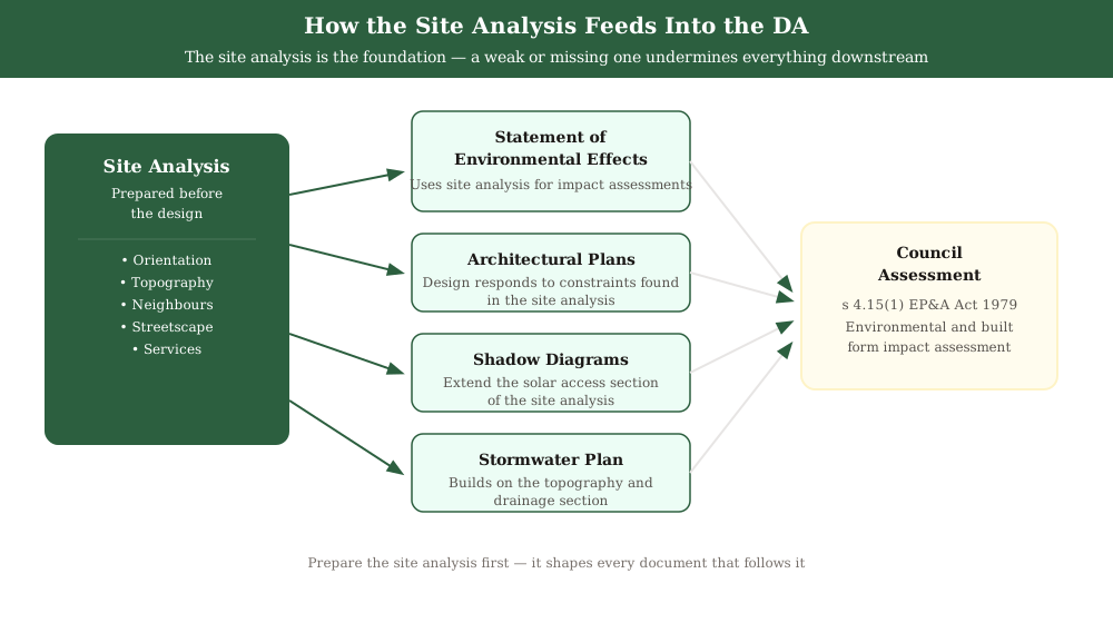
Figure 3: The site analysis feeds into the SEE, the plans, the shadow diagrams, and the stormwater plan.
The site analysis is assessed by council under s 4.15(1) of the Environmental Planning and Assessment Act 1979, which requires the council to consider the impact of the development on the natural and built environment. Because the site analysis shapes everything that follows, it is worth preparing before the design is locked in.
Use the DA lodgement checklist for NSW to confirm the site analysis is included and in the right format before lodging through the NSW Planning Portal at planningportal.nsw.gov.au. The guides to DA supporting documents and SEE requirements in NSW explain how the site analysis connects to the rest of the DA.
Frequently asked questions
Is a site analysis required for all DAs in NSW?
Who prepares a site analysis in NSW?
Does a site analysis need to be a drawing or a written report?
How does the site analysis relate to the Statement of Environmental Effects?
What is a context analysis and is it different from a site analysis?
Ready to get your SEE report?
Skip the writing. Get a DA-ready Statement of Environmental Effects in 5 minutes.
Get your SEE report