Key takeaways
- Wollongong LEP 2009 and DCP 2009 govern most DA assessments
- Illawarra Escarpment slope stability is the primary terrain constraint
- Mine subsidence over former coal workings requires Subsidence Advisory NSW approval
- Coastal hazard land is largely governed by State coastal policy
- Southern Regional Planning Panel determines regionally significant Wollongong DAs
If you are lodging a Development Application with Wollongong City Council, you need a Statement of Environmental Effects. The SEE shows how your proposal complies with the Wollongong Local Environmental Plan 2009 and the Wollongong Development Control Plan 2009, and how it manages its environmental and neighbourhood impacts. Without it, your DA will not be accepted.
Get a council-ready Statement of Environmental Effects for your DA in 5 minutes — no town planner, no waiting.
Get your SEE report →What Is a Statement of Environmental Effects?
A Statement of Environmental Effects is the core planning document every Wollongong DA must include — it is your evidence that the proposal is permissible, compliant, and its impacts manageable.
A Statement of Environmental Effects is required by Schedule 1, Part 1 of the EP&A Regulation 2021 for any development application that requires consent. It demonstrates that you have assessed your proposal against the relevant planning instruments, identified potential impacts, and explained how those impacts will be managed.
For a Wollongong DA, that means working through the Wollongong Local Environmental Plan 2009, the Wollongong Development Control Plan 2009, and any applicable State Environmental Planning Policies (SEPPs). Council officers assess your application against the matters in s 4.15(1) of the EP&A Act 1979, which include the instrument controls, site constraints, neighbour impacts, and public interest.
Wollongong's geography — wedged between the Illawarra Escarpment and the Pacific Ocean, with decades of underground coal mining beneath — means site constraints are more complex here than in most NSW councils. A thorough SEE is not optional: it is the primary document that determines whether your application proceeds.
The Wollongong LEP 2009 — What It Controls
The Wollongong Local Environmental Plan 2009 is the primary statutory instrument governing all land use decisions across the Wollongong local government area.
The Wollongong Local Environmental Plan 2009 (EPI 2010-0076) is a standard instrument plan made under the EP&A Act 1979. It replaced the Wollongong LEP 1990 and applies across the Wollongong local government area, covering the city between the Illawarra Escarpment and the Pacific Ocean — from Helensburgh and Thirroul in the north through the Wollongong CBD, Port Kembla, Corrimal, Dapto, Figtree, Fairy Meadow, Warrawong, Unanderra, and Lake Heights.
The LEP 2009 sets out:
- Land use zones — what development is permissible, permissible with consent, or prohibited on each parcel
- Height of buildings — maximum building heights across the LGA
- Floor space ratio — the maximum gross floor area relative to site area
- Lot size — minimum lot sizes for subdivision and dwelling types
- Heritage — heritage items and conservation areas
- Environmental constraints — escarpment, coastal, and waterway provisions
Some coastal land and State-significant sites may also be governed by State Environmental Planning Policies rather than the LEP, so verifying the applicable instrument for your site is an essential first step.
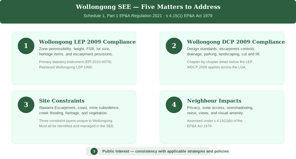 Figure 1: The five core matters a Wollongong SEE must address under the EP&A Act 1979 and the Wollongong LEP 2009.
The Wollongong DCP 2009 — Design and Constraint Controls
Spend 5 minutes, not 3 weeks
instantSEE generates a complete, DA-ready Statement of Environmental Effects online. No town planner. No waiting.
Get your SEE report in 5 minutes →The Wollongong Development Control Plan 2009 provides the detailed design standards and environmental controls that apply across the LGA.
The Wollongong Development Control Plan 2009 (WDCP 2009) provides the chapter-by-chapter controls that translate the LEP zones into built-form outcomes. It covers residential design, commercial standards, landscaping, parking, escarpment land, and drainage.
For residential development, the WDCP 2009 typically addresses:
- Site coverage and impervious area
- Setbacks from boundaries, watercourses, and the escarpment
- Privacy, solar access, and overshadowing
- Parking provision and manoeuvring
- Cut and fill on sloping land
- Native vegetation and clearing controls
For escarpment land, the DCP sets specific controls around slope stability, cut and fill volumes, retaining walls, and visual impact from public places. If your site is within the escarpment, your SEE must address these controls chapter by chapter.
The Illawarra Escarpment — Primary Terrain Constraint
The Illawarra Escarpment defines Wollongong's western boundary and is the most significant terrain constraint for development in the LGA.
The Illawarra Escarpment is a dramatic sandstone and shale formation rising steeply behind the coastal plain. It is mapped as a sensitive area under the Wollongong LEP 2009 and DCP 2009, and development on or near it must address slope stability, landslip risk, native vegetation, and visual impact.
If your site is on or adjacent to the escarpment, your SEE must:
- Identify the escarpment mapping and its relevance to the site
- Assess slope stability and landslip hazard — a geotechnical report is typically required
- Address cut and fill volumes and retaining wall design
- Evaluate the impact on native vegetation, including clearing controls
- Assess the visual impact of the development from public places below
The escarpment is not a blanket prohibition zone, but development must be designed to minimise disturbance and demonstrate that hazard risks are managed to an acceptable level.
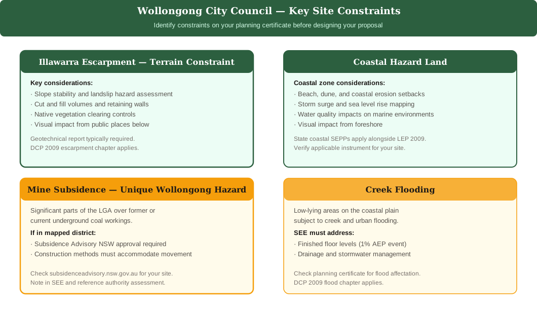 Figure 2: Key site constraints across the Wollongong LGA — Illawarra Escarpment, coast, mine subsidence and flooding.
Mine Subsidence — A Unique Wollongong Constraint
Much of the Wollongong LGA sits above former or current underground coal workings — if your land is in a mapped mine subsidence district, Subsidence Advisory NSW approval may be required.
The Wollongong area has a long history of underground coal mining, and significant parts of the LGA fall within mapped mine subsidence districts. Mine subsidence occurs where underground voids cause the overlying land surface to sink or crack, and it can affect the structural integrity of buildings.
If your site is within a mine subsidence district:
- You must obtain approval from Subsidence Advisory NSW before or alongside your DA
- Your SEE must identify the mine subsidence district and reference the Subsidence Advisory NSW assessment
- Plans and specifications must address any requirements imposed by Subsidence Advisory NSW
- Building construction methods may need to accommodate subsidence movements
Check your planning certificate and the Subsidence Advisory NSW mapping at subsidenceadvisory.nsw.gov.au for your specific site address before beginning your design.
Coastal Land and Hazards
Wollongong's Pacific Ocean frontage means coastal hazard policy and State planning policies for coastal management govern land near beaches, dunes, and the foreshore.
The narrow coastal plain between the Illawarra Escarpment and the ocean means many Wollongong properties are within or adjacent to the coastal zone. Coastal management is largely governed by State Environmental Planning Policies rather than the Wollongong LEP 2009 alone.
For coastal land, your SEE should address:
- Coastal hazard categories — beaches, dunes, coastal erosion, storm surge
- Setbacks from coastal features under the applicable SEPP
- Stormwater management and water quality impacts on marine and estuarine environments
- Visual impact of development from the foreshore and public spaces
Common DA Types in Wollongong
Knowing which DA type applies to your project helps you scope your Wollongong SEE correctly and avoid gaps that slow assessment.
- Wollongong escarpment/sloping land DA · Slope stability and landslip assessment · Cut and fill volumes and retaining walls · Native vegetation and clearing controls · Visual impact from public places · Mine subsidence district check
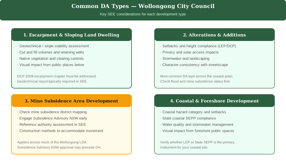 Figure 3: The four most common DA types lodged with Wollongong City Council and the key SEE considerations for each.
The four most common development types lodged with Wollongong City Council are:
- Escarpment and sloping land dwellings — development on or near the Illawarra Escarpment requiring geotechnical assessment, slope stability, and cut-and-fill controls
- Alterations and additions — extensions to existing dwellings across the coastal plain, requiring setback, privacy, and stormwater compliance
- Mine subsidence area development — new structures or substantial works in mapped mine subsidence districts, requiring Subsidence Advisory NSW engagement
- Coastal and foreshore development — development near beaches or the foreshore, requiring coastal hazard and water quality assessment
For each type, the SEE must confirm permissibility, address the relevant LEP and DCP controls, and assess the specific site constraints that apply.
Who Decides Your Wollongong DA?
Understanding who will assess your application helps you pitch your SEE at the right level of detail.
Most Wollongong DAs are assessed by council officers under delegated authority. However, certain applications are referred to higher decision-making bodies:
- Wollongong Local Planning Panel — applications involving variations to development standards, contentious proposals, or those raising significant planning issues
- Southern Regional Planning Panel — regionally significant development, including projects above the capital investment value threshold
Panel applications require a higher level of analytical rigour and may benefit from third-party expert reports — geotechnical, acoustic, traffic, heritage, or coastal — that are referenced and summarised in the SEE.
Before lodging, review the DA lodgement checklist for NSW and the step-by-step guide to lodging a DA in NSW to make sure your application package is complete. For broader context on how SEE requirements vary across councils, see DA requirements across NSW councils.
Frequently asked questions
Do I need a Statement of Environmental Effects for a Wollongong DA?
Which LEP applies to a Wollongong development application?
Is my Wollongong property affected by mine subsidence?
How do I lodge a DA with Wollongong Council?
Ready to get your SEE report?
Skip the writing. Get a DA-ready Statement of Environmental Effects in 5 minutes.
Get your SEE report