Key takeaways
- Shellharbour LEP 2013 governs the fast-growing coastal LGA
- Lake Illawarra foreshore controls apply to nearby development
- Flooding from the lake and creeks triggers finished floor levels
- Calderwood Urban Development Area has its own separate controls
- Illawarra Shoalhaven Regional Planning Panel decides regionally significant DAs
If you are lodging a Development Application with Shellharbour City Council, you need a Statement of Environmental Effects. The SEE shows how your proposal complies with the Shellharbour Local Environmental Plan 2013 and the Shellharbour Development Control Plan, and how it manages its environmental and neighbourhood impacts. Without it, your DA will not be accepted.
Get a council-ready Statement of Environmental Effects for your DA in 5 minutes — no town planner, no waiting.
Get your SEE report →What Is a Statement of Environmental Effects?
A Statement of Environmental Effects is the core planning document every Shellharbour DA must include — it is your evidence that the proposal is permissible, compliant, and its impacts manageable.
A Statement of Environmental Effects is required by Schedule 1, Part 1 of the EP&A Regulation 2021 for any development application that requires consent. It demonstrates that you have assessed your proposal against the relevant planning instruments, identified potential impacts, and explained how those impacts will be managed.
For a Shellharbour DA, that means working through the Shellharbour Local Environmental Plan 2013, the Shellharbour Development Control Plan, and any applicable State Environmental Planning Policies (SEPPs). Council officers assess your application against the matters in s 4.15(1) of the EP&A Act 1979, which include the instrument controls, site constraints, neighbour impacts, and public interest.
Shellharbour is one of the faster-growing coastal local government areas on the Illawarra coast. The SEE must reflect the complexity of a council managing both established residential suburbs near Lake Illawarra and active greenfield release areas like Shell Cove, Flinders, and Calderwood.
The Shellharbour LEP 2013 — What It Controls
The Shellharbour Local Environmental Plan 2013 is the primary statutory instrument governing all land use decisions across the Shellharbour local government area.
The Shellharbour Local Environmental Plan 2013 (EPI 2013-0141) is a standard instrument plan made under the EP&A Act 1979. It covers the entire Shellharbour local government area, including Shellharbour, Shellharbour Village, Albion Park, Oak Flats, Warilla, Shell Cove, and Flinders.
The LEP 2013 sets out:
- Land use zones — what development is permissible, permissible with consent, or prohibited on each parcel
- Height of buildings — maximum building heights across the LGA
- Floor space ratio — the maximum gross floor area relative to site area
- Lot size — minimum lot sizes for subdivision and dwelling types
- Heritage — heritage items and conservation areas protected under the LEP
- Environmental constraints — Lake Illawarra foreshore, coastal land, flood-prone land, and bushfire-prone areas
Note that the Calderwood Urban Development Area operates under its own separate controls — if your site is in Calderwood, verify which instrument applies before you begin your SEE.
Your SEE must address each LEP 2013 clause that applies to your site and your proposal type. Where a development standard applies, your SEE must demonstrate compliance or, if a variation is sought, make the case under an appropriate clause 4.6 variation request.
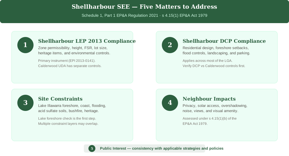 Figure 1: The five core matters a Shellharbour SEE must address under the EP&A Act 1979 and the Shellharbour LEP 2013.
The Shellharbour DCP — Design and Constraint Controls
Spend 5 minutes, not 3 weeks
instantSEE generates a complete, DA-ready Statement of Environmental Effects online. No town planner. No waiting.
Get your SEE report in 5 minutes →The Shellharbour Development Control Plan provides the detailed design standards, environmental controls, and foreshore provisions that apply across most of the LGA.
The Shellharbour Development Control Plan provides the chapter-by-chapter controls that translate the LEP 2013 zones into built-form outcomes. It covers residential design, commercial standards, landscaping, parking, foreshore setbacks, and drainage. Note again that the Calderwood Urban Development Area has its own controls separate from the main Shellharbour DCP.
For residential development, the Shellharbour DCP typically addresses:
- Site coverage and impervious area limits
- Setbacks from boundaries, the lake foreshore, and watercourses
- Privacy, solar access, and overshadowing
- Parking provision and manoeuvring
- Landscaping and tree protection
- Flood controls — finished floor levels and construction materials
Lake Illawarra — Foreshore and Water Quality Controls
Lake Illawarra is the dominant natural feature of the Shellharbour LGA — foreshore setbacks, water quality provisions, and riparian buffer controls apply to any development in proximity to the lake.
Lake Illawarra sits at the heart of the Shellharbour LGA, and its foreshore is both a natural asset and a significant development constraint. Properties near the lake must address:
- Foreshore setbacks — minimum setbacks from the high-water mark and riparian land
- Water quality — stormwater management to prevent nutrient and sediment runoff into the lake
- Riparian buffers — vegetation retention and restoration in lake-adjacent areas
- Visual impact — the lake foreshore is a public amenity and development must respect its visual character
If your site is near Lake Illawarra, your SEE must identify the applicable setback and buffer provisions, explain how the design respects those requirements, and describe the stormwater management measures that will protect water quality during construction and occupation.
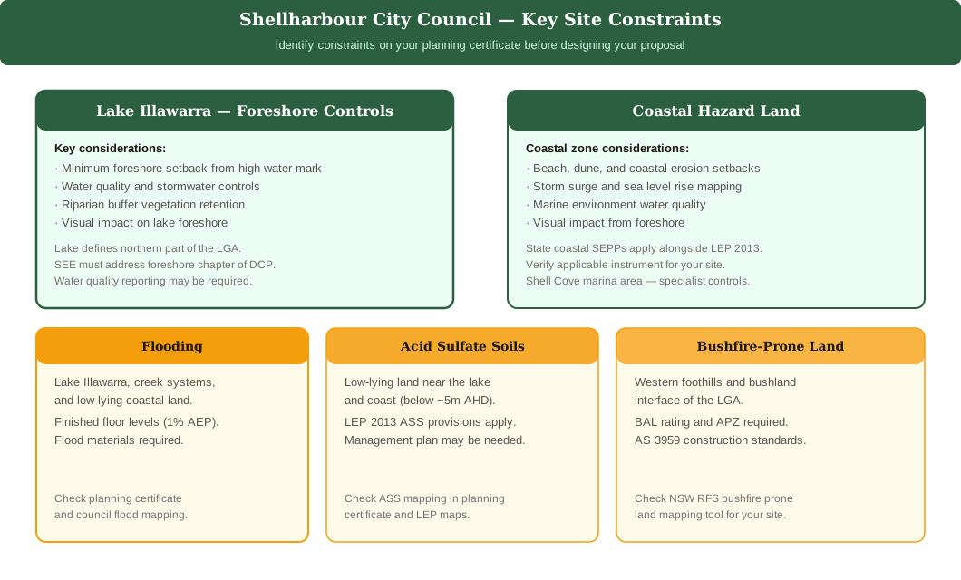 Figure 2: Key site constraints across the Shellharbour LGA — Lake Illawarra foreshore and coast as primary constraints, with flooding, acid sulfate soils, and bushfire as secondary amber hazards.
Flooding — Lake, Creeks, and Low-Lying Land
Flooding from Lake Illawarra, local creeks, and low-lying coastal land affects parts of the Shellharbour area and shapes finished floor levels and construction requirements.
Flooding is a significant planning constraint across parts of the Shellharbour LGA. Low-lying areas near the lake, creek systems, and the coastal plain are within mapped flood planning areas, and the Shellharbour DCP sets minimum finished floor levels referenced to the 1% AEP (100-year) flood event.
If your site is within the flood planning area, your SEE must:
- Identify whether the land is flood-affected and at what flood level
- Address the applicable finished floor level requirements
- Confirm construction materials are appropriate for the flood hazard category
- Demonstrate safe vehicular and pedestrian access and evacuation routes
- Address any impact your development may have on flood behaviour for neighbouring properties
Check your planning certificate and the council flood mapping for your site before beginning your design. Flood affectation is one of the most common reasons Shellharbour DAs require additional information from the applicant.
Coastal Constraints and Acid Sulfate Soils
The Shellharbour coast and low-lying areas carry additional constraints — coastal hazard land is governed partly by State coastal policy, and acid sulfate soils affect low-lying areas near the lake and coast.
Shellharbour's Pacific Ocean frontage means the coastal zone constraints are significant for properties near beaches and dunes. Coastal management is largely governed by State Environmental Planning Policies, and your SEE should address:
- Coastal hazard categories — beach, dune, coastal erosion, storm surge
- Setbacks from coastal features under the applicable SEPP
- Stormwater and water quality impacts on marine environments
Acid sulfate soils are also present in low-lying areas near Lake Illawarra and the coast. If your site may contain acid sulfate soils — typically land below 5 metres AHD — your SEE must address the applicable provisions in the Shellharbour LEP 2013 and any required acid sulfate soils management plan.
Bushfire-Prone Land
The western foothills and bushland interface of the Shellharbour LGA includes bushfire-prone land, triggering Planning for Bush Fire Protection requirements for affected developments.
Development on bushfire-prone land in Shellharbour must comply with the NSW Rural Fire Service's Planning for Bush Fire Protection (PBP) guidelines. If your site is mapped as bushfire-prone:
- Your SEE must address the applicable BAL (Bushfire Attack Level) rating
- Asset Protection Zones must be provided as required by the PBP
- Construction standards under AS 3959 apply
- The NSW RFS must be consulted where required by the EP&A Act 1979
Check the NSW Planning Portal's bushfire prone land mapping tool for your site address.
Common DA Types in Shellharbour
Knowing which DA type applies to your project helps you scope your Shellharbour SEE correctly and avoid gaps that slow assessment.
- Shellharbour foreshore or coastal DA · Lake Illawarra foreshore setback · Finished floor levels (flood planning area) · Coastal hazard land check · Acid sulfate soils on low-lying land · Bushfire-prone land at western interface
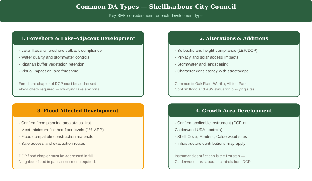 Figure 3: The four most common DA types lodged with Shellharbour City Council and the key SEE considerations for each.
The four most common development types lodged with Shellharbour City Council are:
- Foreshore and lake-adjacent development — new dwellings or alterations near Lake Illawarra, requiring foreshore setbacks, water quality assessment, and riparian buffer compliance
- Alterations and additions — extensions to existing dwellings in established suburbs like Albion Park, Oak Flats, and Warilla, requiring standard DCP compliance
- Flood-affected development — new dwellings or works in the flood planning area, requiring finished floor level compliance and flood impact assessment
- Growth area development — new dwellings in Shell Cove, Flinders, and Calderwood, requiring careful instrument identification and compliance with the applicable controls
For each type, the SEE must confirm permissibility, address the relevant LEP and DCP controls, and assess any site-specific constraints including flooding, foreshore proximity, acid sulfate soils, or bushfire.
Calderwood Urban Development Area
The Calderwood Urban Development Area operates under its own separate planning controls — confirm which instrument governs your Calderwood site before preparing your SEE.
Calderwood is a major urban release area in the western part of the Shellharbour LGA. It operates under its own planning controls — separate from the main Shellharbour DCP — which address the staged delivery of residential, open space, and community infrastructure in the precinct.
If your site is in Calderwood, your SEE must reference the applicable Calderwood controls and demonstrate compliance with the precinct-specific provisions rather than (or in addition to) the Shellharbour DCP.
Who Decides Your Shellharbour DA?
Understanding who will assess your application helps you pitch your SEE at the right level of detail.
Most Shellharbour DAs are assessed by council officers under delegated authority. However, certain applications are referred to higher decision-making bodies:
- Shellharbour Local Planning Panel — applications involving variations to development standards, contentious proposals, or those raising significant planning issues
- Illawarra Shoalhaven Regional Planning Panel — regionally significant development, including projects above the capital investment value threshold
Panel applications require a higher level of analytical rigour and may benefit from third-party expert reports — geotechnical, acoustic, traffic, coastal, or heritage — that are referenced and summarised in the SEE.
Before lodging, review the DA lodgement checklist for NSW and the step-by-step guide to lodging a DA in NSW to make sure your application package is complete. For broader context on how SEE requirements vary across councils, see DA requirements across NSW councils.
Frequently asked questions
Do I need a Statement of Environmental Effects for a Shellharbour DA?
Which LEP applies to a Shellharbour development application?
Is my Shellharbour property flood affected?
How do I lodge a DA with Shellharbour Council?
Ready to get your SEE report?
Skip the writing. Get a DA-ready Statement of Environmental Effects in 5 minutes.
Get your SEE report