Key takeaways
- Kiama LEP 2011 and DCP 2020 govern all DA assessments
- Scenic landscape and visual impact are the primary planning constraints
- Coastal management land is governed largely by State coastal policy
- Rural and dairy land around Jamberoo is protected under the LEP
- Illawarra Shoalhaven Regional Planning Panel decides regionally significant Kiama DAs
A Statement of Environmental Effects (SEE) is a mandatory document for most Development Applications lodged with Kiama Municipal Council. It must demonstrate how your proposal complies with the Kiama Local Environmental Plan 2011 and the Kiama Development Control Plan 2020, and how it manages its environmental and planning impacts across the council's scenic coastal and rural landscape.
Get a council-ready Statement of Environmental Effects for your DA in 5 minutes — no town planner, no waiting.
Get your SEE report →What is a Statement of Environmental Effects for a Kiama DA?
A Statement of Environmental Effects is the planning document that explains your proposal to council and shows how it meets the relevant controls.
Every DA lodged with Kiama Municipal Council that requires development consent must include a Statement of Environmental Effects. The requirement is set by Schedule 1, Part 1 of the EP&A Regulation 2021, which lists the SEE as a mandatory component of any DA. The document must address every matter likely to be relevant to the assessment of your application.
Council assesses your DA under s 4.15(1) of the EP&A Act 1979. That section requires council to consider the provisions of any applicable environmental planning instrument, development control plan, the likely impacts of the development, the suitability of the site, any submissions received, and the public interest. Your SEE must step through each of these matters and explain how your proposal responds to them.
The Kiama LEP 2011 is the primary environmental planning instrument for the area. It is a standard instrument plan made under the EP&A Act 1979 (LEP No 680 / EPI 2011-0680) and replaced the earlier Kiama LEP 1996. It sets your land's zone, height limits, and floor space ratio. The Kiama Development Control Plan 2020 provides the detailed design, landscape, and siting controls that sit beneath the LEP.
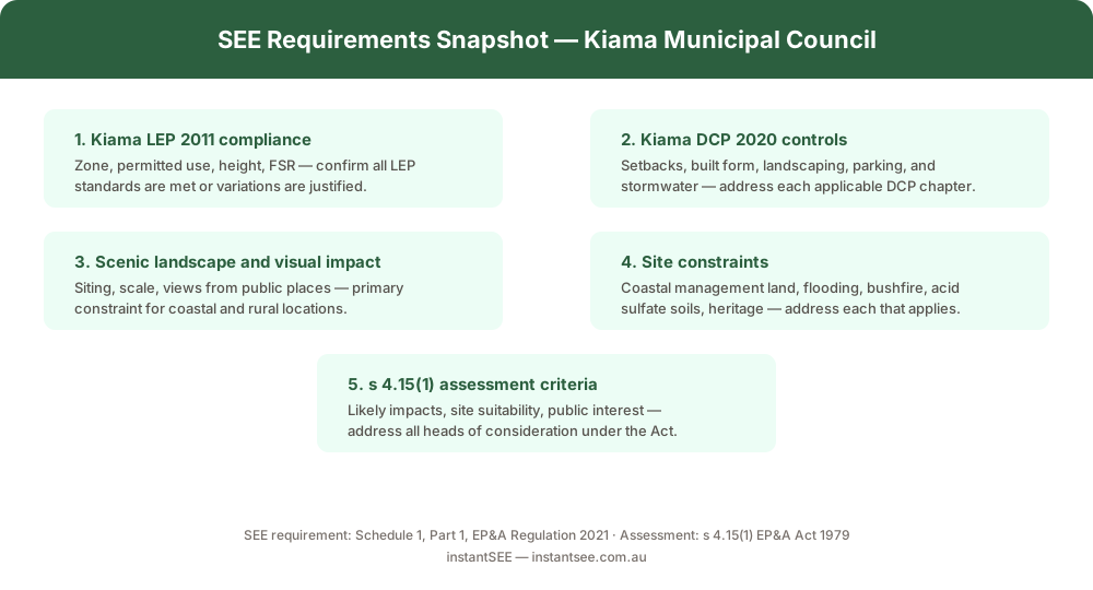 Figure 1: Key matters your SEE must address for a Kiama DA.
What planning controls apply to a Kiama development application?
The Kiama LEP 2011 sets land use zones and development standards; the DCP 2020 adds the detailed design rules your SEE must address.
The Kiama LEP 2011 applies across the whole Kiama municipality, covering the suburbs of Kiama, Kiama Downs, Gerringong, Gerroa, Jamberoo, and Minnamurra. It establishes each parcel's land use zone and the permissibility of different types of development. Before writing your SEE, confirm your zone under the LEP and whether your proposed use is permitted with or without consent.
Where a State Environmental Planning Policy (SEPP) is inconsistent with the Kiama LEP 2011, the State policy prevails. This is particularly significant for land near the coast — State coastal management policies can modify or override LEP controls. Your SEE should identify any applicable SEPPs at the outset, including SEPP (Resilience and Hazards) 2021 for coastal management land and SEPP (Biodiversity and Conservation) 2021 for native vegetation and biodiversity matters.
The Kiama Development Control Plan 2020 applies to all land identified in the Kiama LEP 2011. It contains the detailed controls for setbacks, building height, landscaping, parking, stormwater, and visual impact. Your SEE must address the DCP provisions relevant to your proposal, explain where your design complies, and — where any variation is sought — justify why the variation is appropriate in the circumstances.
What are the key site constraints in the Kiama municipality?
Spend 5 minutes, not 3 weeks
instantSEE generates a complete, DA-ready Statement of Environmental Effects online. No town planner. No waiting.
Get your SEE report in 5 minutes →Scenic landscape, coastal management land, and rural protection are Kiama's signature planning constraints — your SEE must address each that applies to your site.
Kiama's planning environment is shaped by its geography: a prominent scenic coastline, rural hinterland, and dairy farming land around Jamberoo. These characteristics translate into a distinctive set of site constraints that your SEE must address honestly and specifically.
Scenic landscape and visual impact is the primary constraint across much of the municipality. The LEP and DCP 2020 contain provisions protecting scenic and landscape character. Your SEE should assess siting, scale, and how the proposed development reads from public places, roads, and the coast. In prominent coastal or rural locations, a landscape character and visual impact assessment may be required as a separate supporting document.
Coastal management land brings the State coastal policy framework into play. Land within the coastal zone is regulated under SEPP (Resilience and Hazards) 2021, and State coastal management policies can affect setbacks, building envelopes, and permissible land uses. Your SEE must identify whether your site falls within coastal management land and address the relevant State controls.
Rural and agricultural land around Jamberoo is actively protected by the Kiama LEP 2011. The LEP restricts non-rural uses and the fragmentation of agricultural land. If your site is in a rural or primary production zone, your SEE must address the impact of your proposal on the long-term use of the land for agriculture and explain how rural character is protected.
Additional constraints that may apply depending on your site include flooding, bushfire-prone land, and acid sulfate soils (particularly on low-lying coastal or estuarine land). Heritage items and conservation areas are also present across the municipality and trigger additional assessment requirements.
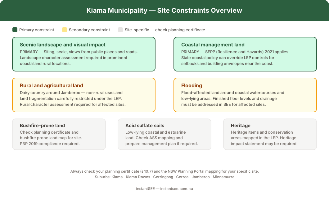 Figure 2: Common site constraints in the Kiama municipality — scenic landscape and coastal management land are the primary considerations.
What types of DAs are commonly lodged with Kiama Council?
From coastal dwellings to rural outbuildings, understanding the most common DA types helps you anticipate what your SEE needs to cover.
The most common Development Applications lodged with Kiama Municipal Council include:
- Dwelling houses and alterations in residential and coastal zones, where the SEE must address DCP controls for setbacks, height, and visual impact from the street and public places.
- Coastal and foreshore development, where SEPP (Resilience and Hazards) 2021 coastal management controls apply in addition to the LEP and DCP.
- Rural residential and agricultural development around Jamberoo and the rural hinterland, where the SEE must address rural land protection, building envelopes, and landscape character.
- Secondary dwellings and dual occupancies, which are assessed against both the LEP permissibility rules and DCP design standards.
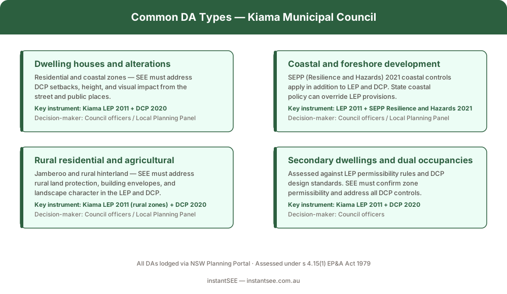 Figure 3: The most common development application types lodged with Kiama Municipal Council.
- Kiama scenic or coastal DA · Visual impact and landscape character assessment · Siting and scale relative to rural or coastal setting · Views from public places and roads · Coastal management land check (State coastal policy) · Bushfire-prone land and acid sulfate soils if applicable
Who decides a Kiama development application?
Most Kiama DAs are determined by council officers, but larger or more complex proposals are referred to a planning panel.
The decision-maker for your Kiama DA depends on the nature, scale, and complexity of the proposal. Council officers determine the majority of routine DAs under delegated authority. More complex or sensitive applications — including those that attract significant public interest or involve variations to development standards — are referred to the Kiama Local Planning Panel.
Regionally significant development is determined by the Illawarra Shoalhaven Regional Planning Panel rather than council. The thresholds for regional significance are set by the State government and typically relate to development cost, capital investment value, or particular land types. Your planning consultant can advise whether your proposal is likely to be assessed at the regional panel level.
How do I lodge a DA with Kiama Council?
All Kiama DAs are lodged online through the NSW Planning Portal — your SEE and supporting documents are uploaded at the time of lodgement.
Development Applications are lodged with Kiama Municipal Council online through the NSW Planning Portal at planningportal.nsw.gov.au. You upload your plans, owner's consent, supporting documents, and your Statement of Environmental Effects, then pay the lodgement fee online.
Council registers your application, issues a formal acknowledgement, and notifies neighbours and other stakeholders where required. The application is then assessed under s 4.15(1) of the EP&A Act 1979. The assessment period varies depending on the complexity of the proposal, whether additional information is required, and whether the application must be referred to other agencies.
For most straightforward residential DAs in Kiama, an assessment period of 40 to 60 business days is common, though complex or contested applications take longer. Preparing a thorough SEE that addresses all relevant matters from the outset — without gaps that require council to request further information — is the most effective way to avoid delays.
Frequently asked questions
Do I need a Statement of Environmental Effects for a Kiama DA?
Which LEP applies to a Kiama development application?
Does scenic and landscape character affect my Kiama DA?
How do I lodge a DA with Kiama Council?
Ready to get your SEE report?
Skip the writing. Get a DA-ready Statement of Environmental Effects in 5 minutes.
Get your SEE report