Key takeaways
- Lane Cove LEP 2009 governs all development across the LGA
- Foreshore building lines apply to Lane Cove River lots
- St Leonards South is the LGA's high-density apartment precinct
- Bushland adjoining Lane Cove National Park triggers biodiversity controls
- Sydney North Planning Panel determines regionally significant applications
If you are lodging a development application with Lane Cove Council, your Statement of Environmental Effects (SEE) must be prepared against the Lane Cove Local Environmental Plan 2009, the Lane Cove Development Control Plan 2009, and the mandatory content requirements of Schedule 1, Part 1 of the Environmental Planning and Assessment Regulation 2021.
Get a council-ready Statement of Environmental Effects for your DA in 5 minutes — no town planner, no waiting.
Get your SEE report →- Which planning instruments apply to Lane Cove Council DAs
- How the Lane Cove River foreshore and building lines affect your SEE
- What bushland adjoining Lane Cove National Park means for biodiversity
- How the St Leonards South high-density precinct shapes built-form assessment
- When the Sydney North Planning Panel determines applications
What Planning Instruments Govern Lane Cove DAs?
The Lane Cove LEP 2009 — a standard instrument plan made under the EP&A Act 1979 — is the primary planning instrument for the LGA, supplemented by the Lane Cove DCP 2009's detailed design controls for each zone and development type.
The Lane Cove Local Environmental Plan 2009 is the principal legal document controlling development across the Lane Cove local government area. It sets land use permissibility, height of buildings, floor space ratio, heritage controls, and environmental protections across Lane Cove, Lane Cove West, Lane Cove North, Greenwich, Longueville, Northwood, Riverview, and parts of St Leonards.
The Lane Cove Development Control Plan 2009 provides detailed design standards for each development type and zone. Your SEE must demonstrate compliance with both instruments and with any applicable State Environmental Planning Policies. The mandatory content floor is set by Schedule 1, Part 1 of the EP&A Regulation 2021, and Council's assessment is framed by s 4.15(1) of the EP&A Act 1979.
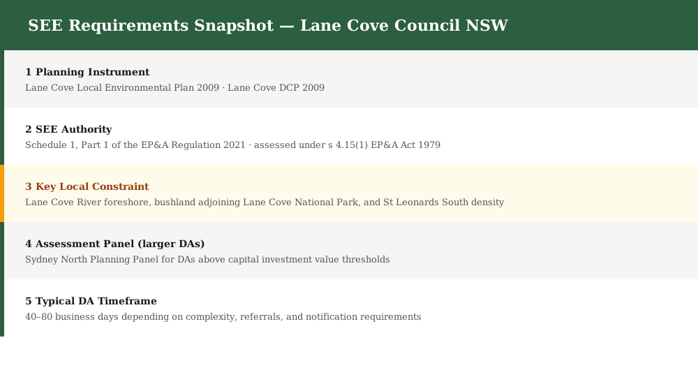
Figure 1: Key planning instruments and SEE content requirements for Lane Cove Council DAs.
Lane Cove River Foreshore and Building Lines
The Lane Cove River foreshore is the defining natural feature of the LGA, and foreshore building lines, riparian corridors, flooding, and stormwater controls must be addressed in any SEE for a river-adjacent or near-water site.
Lane Cove wraps around the Lane Cove River, and the river foreshore shapes the character of the entire municipality. The LEP 2009 maps foreshore building lines, riparian corridors, and environmental protection zones along the river's edge. Any DA within or adjacent to these areas must address:
- Compliance with the foreshore building line for the site
- Riparian corridor setbacks and vegetation retention
- Flooding and overland flow impacts and finished floor levels
- Stormwater quality and runoff to the waterway
- Visual impact on the river foreshore and public domain
Bushland and Biodiversity — Lane Cove National Park Interface
Spend 5 minutes, not 3 weeks
instantSEE generates a complete, DA-ready Statement of Environmental Effects online. No town planner. No waiting.
Get your SEE report in 5 minutes →Lane Cove adjoins Lane Cove National Park, and urban bushland along the river corridor is protected through environmental protection zones and DCP tree controls — biodiversity assessment is a key SEE obligation for park-adjacent and bushland-fringe properties.
The Lane Cove LGA includes significant areas of urban bushland, including the foreshore bushland that connects to Lane Cove National Park. The LEP 2009 maps environmental protection zones, and the Biodiversity Conservation Act 2016 provides an overlay of statutory protection.
Your SEE must address biodiversity and vegetation impacts where:
- The site abuts or is within a mapped sensitive area or environmental protection zone
- Vegetation is proposed to be cleared (including under the tree preservation provisions of the DCP 2009)
- The site is within a riparian or ecological buffer zone
- Identify bushland and tree coverage on and adjoining the site · Check the LEP 2009 mapping for environmental protection zones and buffers · Confirm whether the Biodiversity Offset Scheme threshold is triggered · Commission an arborist report for any trees in or near the development footprint · Address vegetation retention, replacement planting, and canopy in the SEE
St Leonards South and the Town Centre
St Leonards South is Lane Cove's high-density apartment precinct along the Pacific Highway, where built form, height, FSR, overshadowing, and traffic are central SEE considerations — distinct from the low-density suburban and bushland character of most of the LGA.
The St Leonards South precinct, extending along the Pacific Highway into the former Gore Hill and St Leonards corridor, is the LGA's primary high-density precincts. DAs in this precinct must address LEP height and FSR controls, active street frontages, pedestrian connectivity, overshadowing impacts on neighbours and the public domain, and traffic and parking.
The Lane Cove town centre itself, clustered around the Lane Cove Village shopping strip, is the local commercial hub. DAs in the village must address built form, streetscape, parking, and retail amenity.
Heritage and Site Constraints
Heritage items and conservation areas are mapped across the LGA under the Lane Cove LEP 2009, and steep ridge-and-valley terrain adjacent to the river means geotechnical issues recur in a significant share of Lane Cove DAs.
The LEP 2009 Schedule 5 maps heritage items and conservation areas across Lane Cove. Work in or adjacent to listed items or conservation areas must include a heritage impact assessment as part of the SEE.
Steep ridgeline and valley-side properties, particularly near the river corridor, regularly require geotechnical assessment where excavation, retaining walls, or substantial earthworks are proposed.
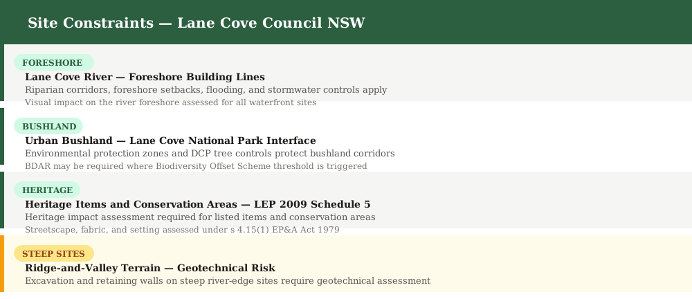
Figure 2: Key site constraints that must be addressed in a Lane Cove Council SEE.
Common DA Types in Lane Cove
Alterations and additions in established residential streets, high-density apartments in St Leonards South, river foreshore works, and bushland-edge residential development are the most common DA types lodged with Lane Cove Council.
Lane Cove's LGA encompasses quiet, tree-lined suburban streets in Greenwich, Longueville, and Northwood, the high-density St Leonards South precinct along the Pacific Highway, and the Lane Cove River foreshore. Each development type requires specific SEE content.
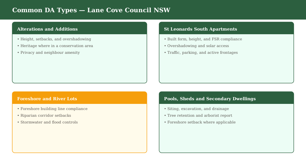
Figure 3: Common development application types lodged with Lane Cove Council.
When Does the Sydney North Planning Panel Decide?
Larger or more complex DAs in Lane Cove are determined by the Sydney North Planning Panel when capital investment value thresholds are met or other statutory triggers apply.
The Sydney North Planning Panel (SNPP) has jurisdiction over Lane Cove Council DAs where the capital investment value exceeds specified thresholds, where Council is the applicant or landowner in the mid-range, or for sensitive, Crown, or designated development. For SNPP applications, the SEE must meet a higher evidential standard and be supported by comprehensive technical reports.
Frequently asked questions
Do I need a Statement of Environmental Effects for a Lane Cove DA?
Which LEP applies to a Lane Cove development application?
Does the foreshore building line affect my Lane Cove DA?
Is my Lane Cove property affected by bushland or biodiversity controls?
Can instantSEE prepare a SEE for a Lane Cove DA?
Ready to get your SEE report?
Skip the writing. Get a DA-ready Statement of Environmental Effects in 5 minutes.
Get your SEE report