Key takeaways
- Hunters Hill LEP 2012 covers this heritage-rich peninsula municipality
- Heritage controls are among the strictest in NSW
- Lane Cove and Parramatta rivers create foreshore building line obligations
- Steep ridge-and-slope terrain triggers geotechnical assessment requirements
- Sydney North Planning Panel determines regionally significant applications
If you are lodging a development application with Hunters Hill Council, your Statement of Environmental Effects (SEE) must be prepared against the Hunters Hill Local Environmental Plan 2012, the Hunters Hill Development Control Plan, and the mandatory content requirements of Schedule 1, Part 1 of the Environmental Planning and Assessment Regulation 2021.
Get a council-ready Statement of Environmental Effects for your DA in 5 minutes — no town planner, no waiting.
Get your SEE report →- Which planning instruments apply to Hunters Hill Council DAs
- How heritage conservation areas define SEE requirements across the LGA
- What the Lane Cove and Parramatta River foreshore means for your DA
- How steep peninsula terrain shapes geotechnical obligations
- When the Sydney North Planning Panel determines applications
What Planning Instruments Govern Hunters Hill DAs?
The Hunters Hill LEP 2012 — a standard instrument plan made under the EP&A Act 1979 — is the primary planning instrument for the Municipality of Hunters Hill, supplemented by the Hunters Hill DCP's detailed heritage, foreshore, and design controls.
The Hunters Hill Local Environmental Plan 2012 is the principal legal document controlling development across the Municipality of Hunter's Hill. It applies to Hunters Hill, Woolwich, Henley, Huntleys Point, and Huntleys Cove, setting land use permissibility, height of buildings, floor space ratio, heritage items, and conservation areas.
The Hunters Hill Development Control Plan provides detailed design and heritage standards for each development type and zone. Your SEE must demonstrate compliance with both instruments and with any applicable State Environmental Planning Policies. The mandatory content floor is set by Schedule 1, Part 1 of the EP&A Regulation 2021, and Council's assessment is framed by s 4.15(1) of the EP&A Act 1979.
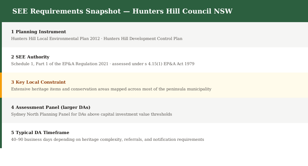
Figure 1: Key planning instruments and SEE content requirements for Hunters Hill Council DAs.
Heritage — One of NSW's Most Heritage-Rich Councils
Hunters Hill is one of Australia's oldest garden suburbs, and heritage conservation areas and listed items are mapped across most of the municipality — heritage impact assessment is the central SEE obligation for the majority of DAs lodged in the LGA.
Heritage protection is the defining SEE obligation across Hunters Hill. The LEP 2012 maps heritage items and heritage conservation areas (HCAs) across the municipality. Conservation areas and listed items cover the great majority of the peninsula. Any DA that affects a heritage item or involves work within a HCA must include a heritage impact statement (HIS) as part of the SEE.
A heritage impact statement must:
- Identify the significance of the heritage item or conservation area
- Describe all proposed works including materials, colours, and finishes
- Assess impact on heritage significance, fabric, setting, and views
- Propose mitigation measures and sympathetic design treatments
- Include archival recording if any heritage fabric is to be removed
- Identify whether the property is a heritage item or within a heritage conservation area · Check the significance level of the item or HCA in the LEP 2012 schedule · Confirm the scope of proposed works and any demolition · Commission a heritage impact statement from a qualified heritage consultant · Address streetscape, setting, materials, and cumulative heritage impact in the SEE
Lane Cove and Parramatta River Foreshore
Spend 5 minutes, not 3 weeks
instantSEE generates a complete, DA-ready Statement of Environmental Effects online. No town planner. No waiting.
Get your SEE report in 5 minutes →Hunters Hill is a peninsula bounded by the Lane Cove River to the north and east and the Parramatta River to the south, and foreshore building lines, riparian corridors, and flooding controls apply to a substantial share of lots across the municipality.
The foreshore is the second major constraint after heritage. The LEP 2012 maps foreshore building lines along both the Lane Cove River and the Parramatta River shorelines, and riparian land with its associated vegetation, flooding, and stormwater controls is mapped throughout.
Any DA on a foreshore-adjacent lot must address:
- Compliance with the foreshore building line for the site
- Riparian corridor setbacks and vegetation retention
- Flooding and tidal inundation impacts
- Visual impact on the river and harbour foreshore
- Public access to the foreshore where relevant
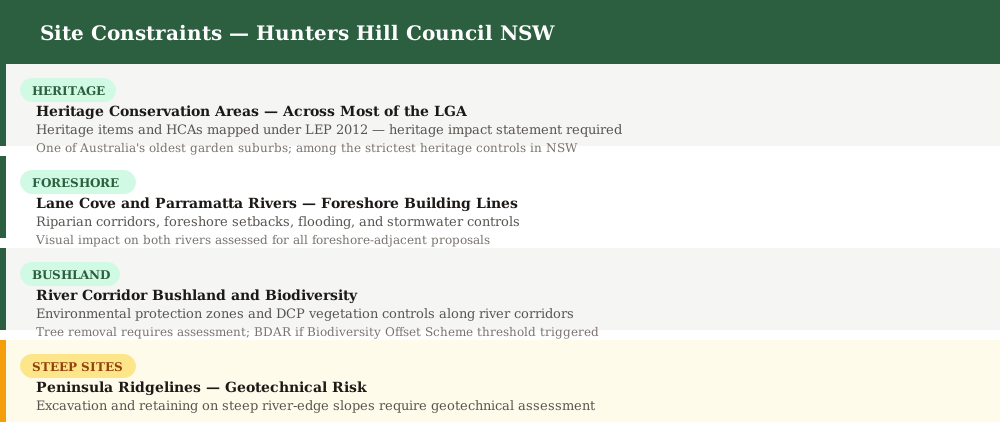
Figure 2: Key site constraints that must be addressed in a Hunters Hill Council SEE.
Steep Terrain and Geotechnical Considerations
Hunters Hill is a peninsula of steep ridgelines and valley slopes running down to both rivers, and geotechnical assessment is regularly required for excavation, retaining walls, and basement works across the LGA.
The ridge-and-slope topography of the Hunters Hill peninsula means that excavation, deep footings, retaining walls, and substantial earthworks frequently require geotechnical assessment. This is particularly acute for properties in Woolwich, Henley, Huntleys Point, and Huntleys Cove, where steep ground runs directly to the river foreshore.
Common DA Types in Hunters Hill
Heritage alterations and additions are by far the most common DA type in Hunters Hill, followed by new dwellings, foreshore works, and secondary dwellings — each requiring specific SEE content under the LEP 2012 and DCP.
Hunters Hill's LGA is almost entirely low-density residential, with heritage and foreshore overlays across most of the peninsula. The DA types reflect that character.
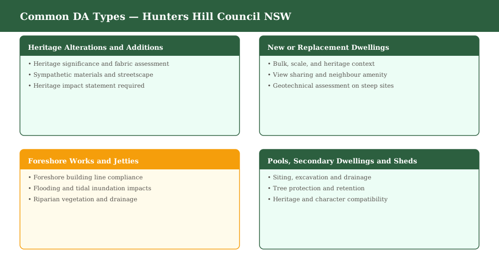
Figure 3: Common development application types lodged with Hunters Hill Council.
When Does the Sydney North Planning Panel Decide?
Larger DAs in Hunters Hill are determined by the Sydney North Planning Panel when capital investment value thresholds or other statutory triggers are met — for SNPP applications the SEE must meet a higher evidential standard.
The Sydney North Planning Panel (SNPP) has jurisdiction over Hunters Hill Council DAs where the capital investment value exceeds specified thresholds, or for sensitive, Crown, or designated development. Heritage matters are frequently before the Hunters Hill Local Planning Panel.
Frequently asked questions
Do I need a Statement of Environmental Effects for a Hunters Hill DA?
Which LEP applies to a Hunters Hill development application?
Is my Hunters Hill property heritage listed or in a conservation area?
Does the foreshore building line affect my Hunters Hill DA?
Can instantSEE prepare a SEE for a Hunters Hill DA?
Ready to get your SEE report?
Skip the writing. Get a DA-ready Statement of Environmental Effects in 5 minutes.
Get your SEE report