Key takeaways
- Section 10.7 certificate reveals mapped constraints that trigger the report
- Steep slopes, fill, and flood land are the most common triggers
- Only a geotechnical engineer can prepare the report
- Bearing capacity findings directly determine footing type and cost
- Contamination discovered during investigation adds further assessment steps
A geotechnical report — also called a site investigation or soil report — tells your council and your engineers what lies beneath the surface of your site and whether it can safely support the proposed development. It is required whenever ground conditions create uncertainty about stability, bearing capacity, drainage, or contamination. Missing one when it is needed can halt a DA mid-assessment and delay the construction certificate.
Get a council-ready Statement of Environmental Effects for your DA in 5 minutes — no town planner, no waiting.
Get your SEE report →- When a geotechnical report is required for a NSW DA
- How to identify whether your site has mapped constraints
- What a geotechnical engineer investigates and reports
- How geotechnical findings feed into structural and civil engineering design
- How the report fits alongside your SEE in the DA package
When Is a Geotechnical Report Required?
The requirement is not set by a single state law — it flows from your council's DCP, the Building Code of Australia, and site-specific constraints that a Section 10.7 Planning Certificate will reveal before you commit to a design.
No single piece of NSW state legislation specifies a universal geotechnical report threshold. The obligation comes from your council's Development Control Plan (DCP), the Building Code of Australia (BCA), and the site-specific conditions revealed during a pre-application check or planning certificate search.
Common triggers are: steeply sloping land — many councils require a geotechnical report for sites with a gradient steeper than one vertical in four horizontal; known or suspected filled land, common on former market garden sites, reclaimed land, and properties near creek lines; flood-prone land where the ground composition affects flood behaviour and foundation performance; sites with a history of industrial use where contamination is possible; and multi-storey or basement construction where loads on the ground significantly exceed those of a conventional single dwelling.
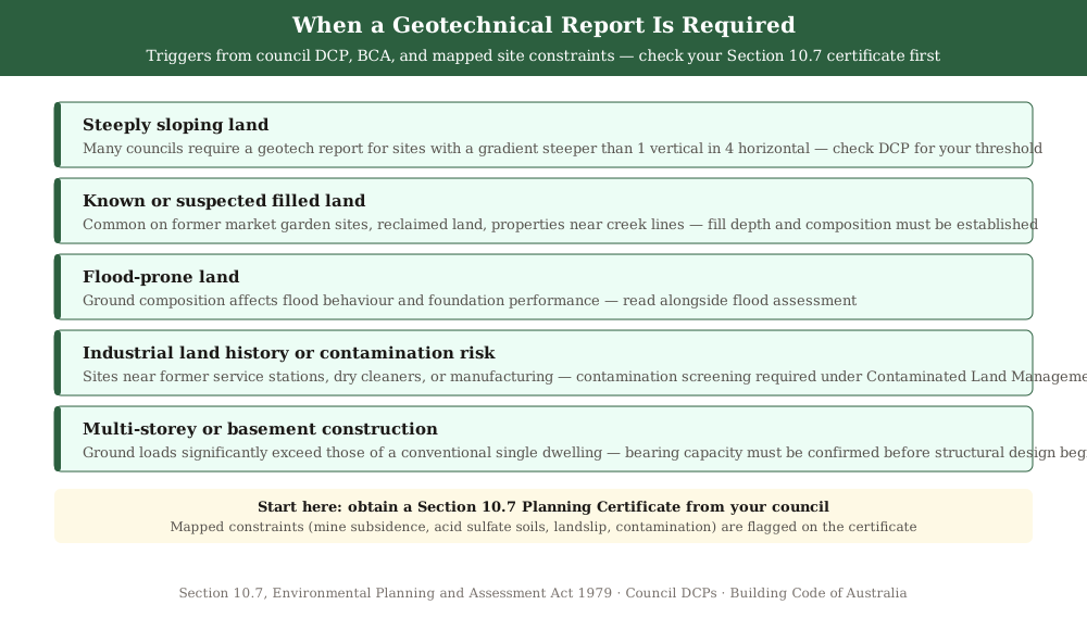 Figure 1: Common triggers for a geotechnical report. Your council DCP will specify exact thresholds for your site.
A Section 10.7 Planning Certificate (formerly s 149 certificate) from your council will flag whether your land is affected by any mapped constraints — mine subsidence, contaminated land, acid sulfate soils, or landslip hazard — that will trigger a geotechnical investigation. Obtain one before you commit to a design.
What a Geotechnical Report Covers
A geotechnical report requires on-site drilling or test pits, laboratory analysis, and engineering interpretation — it is not a desktop study and cannot be rushed without compromising the quality of the findings.
A geotechnical report for a NSW DA is prepared by a geotechnical engineer — a specialist civil engineer with expertise in soil and rock mechanics. It requires on-site investigation, typically involving drilling boreholes or excavating test pits to retrieve soil samples, followed by laboratory testing and engineering analysis.
The report typically addresses: the soil and rock profile beneath the site, described by type, depth, and engineering properties; bearing capacity — the load per square metre the ground can safely support — which determines footing type and depth; slope stability analysis for sites with significant grade changes; groundwater depth and its seasonal variation; drainage characteristics, including the rate at which water moves through the soil; and a contamination screening assessment if the site has any industrial history or sits adjacent to a known contaminated site.
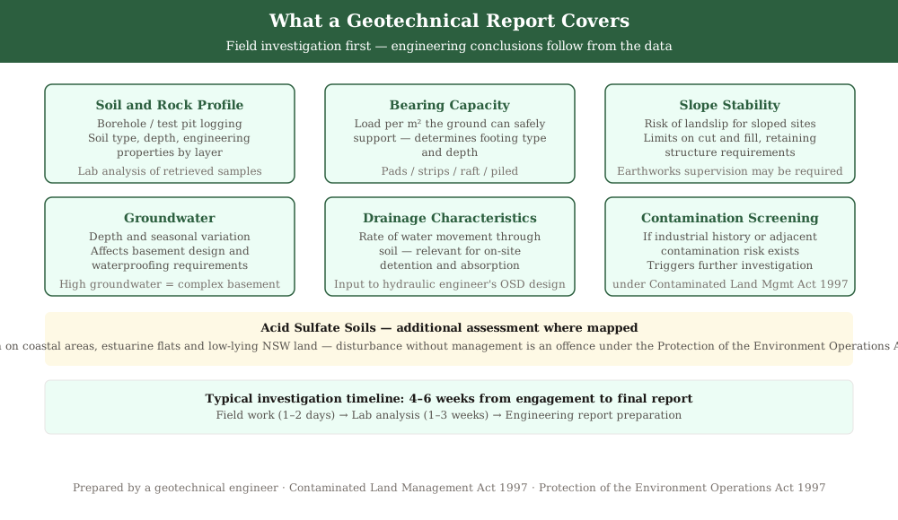 Figure 2: The core elements of a geotechnical report. Field investigation comes first; engineering conclusions follow.
For sites on known acid sulfate soils — mapped across many coastal areas, estuarine flats, and low-lying areas of NSW — the geotechnical report will also include an acid sulfate soil risk assessment and management recommendations. Disturbing acid sulfate soils without management causes acidification of surrounding waterways, which is an offence under the Protection of the Environment Operations Act 1997.
- Obtain a Section 10.7 Planning Certificate to identify mapped constraints before commissioning designs
- Check the council DCP for the gradient threshold and other site-specific triggers
- Engage a registered geotechnical engineer to prepare the investigation
- Confirm whether acid sulfate soils mapping applies to your site
- Allow 4 to 6 weeks from engagement to report
How Geotechnical Findings Drive Engineering Design
Spend 5 minutes, not 3 weeks
instantSEE generates a complete, DA-ready Statement of Environmental Effects online. No town planner. No waiting.
Get your SEE report in 5 minutes →Geotechnical findings are the input for every major engineering decision in your DA — bearing capacity determines footing type, stability findings set the limits on cut and fill, and contamination findings add remediation steps.
A geotechnical report does not stand alone — it is the input document for your structural engineer's footing design, your civil engineer's retaining wall and drainage design, and in some cases your hydraulic engineer's OSD sizing. The quality of the geotechnical investigation directly determines the reliability of those downstream designs.
Bearing capacity recommendations translate directly into footing type — pad footings, strip footings, raft, or piled. A site with soft or fill material may require piles that add significantly to construction cost. Knowing this before you finalise the design prevents costly redesigns after the DA is lodged.
Slope stability findings determine where cut and fill are permissible, what retaining structures are needed, and whether the slope requires ongoing monitoring during construction. Councils in landslip-prone areas — the Blue Mountains, northern Sydney slopes, Illawarra escarpment — will require stability findings as a condition of consent, often including a recommendation that a geotechnical engineer supervise bulk earthworks.
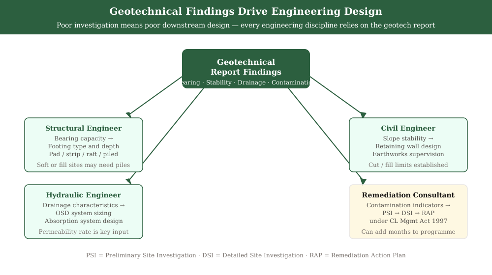 Figure 3: Geotech findings drive every engineering discipline on the DA. Poor investigation means poor downstream design.
Where contamination is identified, the geotechnical report will recommend further investigation under the Contaminated Land Management Act 1997 before the DA can be determined. This adds a remediation assessment step — potentially a Preliminary Site Investigation, Detailed Site Investigation, and Remediation Action Plan — that needs to be scoped into the project programme.
How a Geotechnical Report Fits Your DA and SEE
The geotechnical report is a technical supporting document lodged with your DA — your SEE summarises the findings and confirms the development is suitable for the site's ground conditions, consistent with all other technical reports in the package.
The geotechnical report is lodged as part of your DA package through the NSW Planning Portal. Your Statement of Environmental Effects summarises the geotechnical findings, references the report, and addresses ground conditions as one of the environmental impacts assessed under s 4.15(1) of the Environmental Planning and Assessment Act 1979. The SEE should confirm that the proposed development is suitable for the site's ground conditions and that risks identified in the report are managed through engineering design.
Where the site is flood-prone, the geotechnical report is read alongside a flood report. Where contamination is a risk, it is read alongside a preliminary site investigation under NSW EPA guidelines. Your SEE needs to reflect the findings of all these reports consistently — council assessment officers check whether supporting documents tell the same story.
For a full overview of what to lodge, use the DA lodgement checklist for NSW and our guide to DA supporting documents.
Frequently asked questions
Do I need a geotechnical report for a single-storey house on a flat block in NSW?
Who prepares a geotechnical report for a NSW DA?
How long does a geotechnical investigation take?
What happens if contamination is found during the investigation?
Can the geotechnical report be prepared after DA lodgement?
Ready to get your SEE report?
Skip the writing. Get a DA-ready Statement of Environmental Effects in 5 minutes.
Get your SEE report