Key takeaways
- Every Warrumbungle DA requiring consent needs a Statement of Environmental Effects
- Your SEE must address the Warrumbungle LEP 2013 and DCP 2015
- Dark-sky lighting near Siding Spring is a distinctive local control
- Bushfire, felt in the 2013 Wambelong fire, shapes rural SEEs
- Most Warrumbungle DAs are decided by a council officer
A Statement of Environmental Effects for a Warrumbungle Shire Council Development Application must show how your proposal sits with the Warrumbungle Local Environmental Plan 2013 and the applicable State policies, and how it manages its impacts on neighbours and the surrounding area. Every DA lodged with Warrumbungle Shire Council that needs consent must include one, and it is the document the council reads to understand your project.
Warrumbungle Shire is central-west and Orana country centred on Coonabarabran, with Coolah, Dunedoo, Binnaway and Baradine across a large rural shire. It is famous for two things above ground and one below: the jagged Warrumbungle National Park, the Siding Spring Observatory that sits within it — Australia's premier optical astronomy site and the heart of the country's first Dark Sky Park — and the Pilliga forest to the west. The 2013 Wambelong fire tore through the park and nearby properties, and bushfire is front-of-mind here.
Get a council-ready Statement of Environmental Effects for your DA in 5 minutes — no town planner, no waiting.
Get your SEE report →- What a Warrumbungle SEE must address under section 4.15 of the EP&A Act
- The council's common zones and the overlays that commonly bite here
- The common DA types locally and what each SEE focuses on
- How to lodge your DA through the NSW Planning Portal step by step
- Who determines your application — officer, panel, or State body
What Warrumbungle Shire Council Requires in a SEE
Your SEE must address five matters that map directly onto the section 4.15 assessment the council runs — planning-instrument compliance, control-plan compliance, site constraints, neighbour impacts, and the public interest.
Your Statement of Environmental Effects for a Warrumbungle DA must address five things: how your proposal complies with the Warrumbungle Local Environmental Plan 2013, how it meets the Warrumbungle Shire Development Control Plan 2015, the constraints on your specific site, the impacts on your neighbours, and the public interest. These map directly onto the matters a council must weigh under section 4.15 of the Environmental Planning and Assessment Act 1979.
The council's principal planning instrument is the Warrumbungle Local Environmental Plan 2013, supported by the Warrumbungle Shire Development Control Plan 2015. The LEP sets your land's zone and the development standards that come with it, such as height and minimum lot size. The control plan then sets the design detail: setbacks, landscaping, private open space, parking and privacy, along with hazard controls where they apply. Your SEE needs to walk through each control that applies and either show you comply or justify the variation.
Common Zones and Overlays in Warrumbungle
Your zone sets what you can build, but the constraint that shapes a Warrumbungle SEE is usually one of the mapped overlays over the top of it.
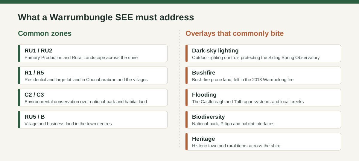
Figure 1: The zones and mapped constraints a Warrumbungle SEE most often has to address.
Under the Warrumbungle LEP 2013 most land is zoned RU1 Primary Production or RU2 Rural Landscape across the shire, with R1/R5 residential and large-lot land in Coonabarabran and the villages and C2/C3 conservation land over national-park and habitat country. The constraints mapped over the top are where a Warrumbungle SEE really lives, and one of them is genuinely unusual. Outdoor lighting matters here because of the Siding Spring Observatory: the shire and State planning controls limit light spill to protect the dark night sky that makes the observatory work, so a SEE for development that involves external lighting should address how it minimises light pollution. Bush-fire prone land is extensive and the 2013 Wambelong fire, which burned through the national park and destroyed homes near Coonabarabran, makes asset-protection zones and access a live issue on rural and fringe sites. Flooding on the Castlereagh and Talbragar systems, biodiversity at the national-park and Pilliga interfaces, and heritage in the towns round out the constraints. A SEE that names the specific constraint on your lot is far stronger than one that speaks in generalities.
Common DA Types in Warrumbungle and What Your SEE Must Address
Spend 5 minutes, not 3 weeks
instantSEE generates a complete, DA-ready Statement of Environmental Effects online. No town planner. No waiting.
Get your SEE report in 5 minutes →The focus of your SEE shifts with the project type, so the same five section 4.15 matters get different weight depending on what you are building.
For alterations and additions in Coonabarabran or Coolah, the SEE concentrates on lighting, height, setbacks and streetscape. For a new dwelling or shed on rural land, it focuses on siting, bushfire, lighting, effluent and access. For a secondary dwelling, the focus is floor area, private open space and servicing. For any proposal with external lighting, dark-sky controls lead. A DA lodgement checklist for NSW helps you gather the right supporting documents for each.
How to Lodge a DA with Warrumbungle Shire Council
You lodge every Warrumbungle DA through the NSW Planning Portal — upload your plans, SEE, owner's consent, and pay the fee; the council registers it and notifies neighbours before assessment begins.
You lodge a Warrumbungle DA through the NSW Planning Portal at planningportal.nsw.gov.au, the system every NSW council uses. You upload your plans, owner's consent, supporting documents and your SEE, then pay the fee. Our step-by-step guide to lodging a DA in NSW covers the portal mechanics.
Once lodged, the council registers your DA, notifies adjoining owners where required, and assesses it against section 4.15. Warrumbungle Shire Council is the consent authority for most local development, so most DAs are decided by a council officer under delegated authority or by the elected council, while regionally significant development is determined by the Western Regional Planning Panel. For a typical extension, dwelling or shed, expect a council officer to determine it. The biggest cause of delay is an incomplete application or a SEE that does not address the controls, which triggers a request for more information. The general DA requirements across NSW councils follow the same legislative base, so a complete Warrumbungle lodgement looks much like any other.
Do You Need a Town Planner for a Warrumbungle DA?
For a straightforward residential DA you can prepare the SEE yourself or use a service; a planner earns its keep on the harder, constrained sites.
Not always. For a straightforward residential DA in Warrumbungle — a single-storey addition, a dwelling on a serviced lot, a shed — you can prepare the SEE yourself or use a service rather than engaging a town planner. You are more likely to want a planner where the project is complex: a bushfire-constrained site, a proposal with significant external lighting near the observatory, a heritage property, or one that seeks to vary a development standard. For the common residential cases, a well-structured SEE that addresses the Warrumbungle LEP 2013 and DCP 2015 is what you need.
Frequently asked questions
Do I need a Statement of Environmental Effects for a Warrumbungle DA?
Which LEP applies to a Warrumbungle development application?
Do I need to address outdoor lighting for a Warrumbungle DA?
Who decides my Warrumbungle DA?
Ready to get your SEE report?
Skip the writing. Get a DA-ready Statement of Environmental Effects in 5 minutes.
Get your SEE report