Key takeaways
- No single Northern Beaches LEP — three former-council plans apply
- Coastal hazards and foreshore controls apply near the water
- Bushfire-prone land triggers RFS requirements across the LGA
- Flooding affects low-lying land near creeks and the Pittwater estuary
- Sydney North Planning Panel determines larger Northern Beaches DAs
Northern Beaches Council presents a planning challenge that most LGAs in NSW do not: there is no single operative Local Environmental Plan. When the former Manly, Warringah, and Pittwater councils merged in May 2016, their separate LEPs remained in force — and they remain in force today. Before you can write a meaningful Statement of Environmental Effects (SEE) for a Northern Beaches DA, you need to know which LEP applies to your land. Then the real work begins: coastal hazards, widespread bushfire-prone land, flooding, and a fragmented DCP landscape demand careful attention at every stage.
Get a council-ready Statement of Environmental Effects for your DA in 5 minutes — no town planner, no waiting.
Get your SEE report →What Planning Instruments Govern Northern Beaches DAs?
The planning framework for Northern Beaches DAs is more complex than for any single-LEP council. Understanding the instrument hierarchy before you write a word of your SEE is essential.
The legal content requirement for every SEE lodged with Northern Beaches Council flows from Schedule 1, Part 1 of the EP&A Regulation 2021. Regardless of which former-council area your land falls in, the SEE must address the prescribed matters in that schedule — environmental impacts, consistency with the relevant planning instruments, site suitability, and the public interest.
Council assesses the application against s 4.15(1) of the EP&A Act 1979, which requires consideration of the provisions of the applicable LEP and DCP, the likely impacts on the built and natural environment, site suitability, any submissions received, and the public interest.
State Environmental Planning Policies may also overlay Northern Beaches sites — particularly the coastal SEPP, biodiversity SEPP, and housing-related SEPPs. Verify applicable overlays on the NSW Planning Portal for your specific address before finalising your SEE.
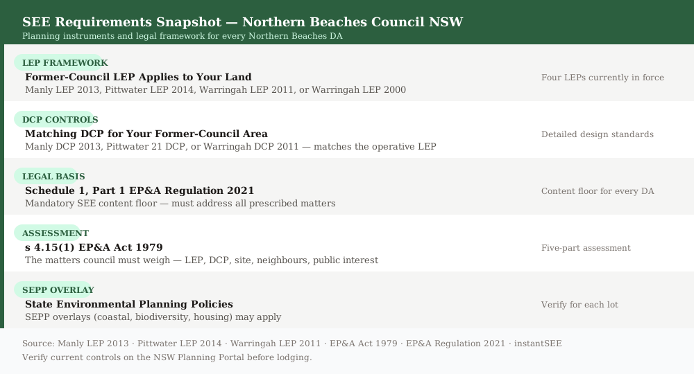 Figure 1: The planning instruments and legal framework that govern every Northern Beaches DA.
Which LEP Applies to Your Northern Beaches DA?
This is the question that catches applicants out. Getting the wrong LEP wrong in your SEE is a fundamental error — and one of the most common reasons Northern Beaches DAs are returned for further information.
Northern Beaches Council was formed on 12 May 2016 from the merger of the former Manly, Warringah, and Pittwater councils. No single consolidated Northern Beaches LEP is yet in force. A consolidated Northern Beaches LEP is the subject of a Planning Proposal. A Gateway determination was issued on 14 October 2025 and public exhibition is anticipated in 2026 — but the consolidated LEP has not yet commenced and carries no legal weight for current DAs.
The operative LEP for your DA is one of the following four instruments:
- Manly Local Environmental Plan 2013 — applies to the former Manly Council area, including Manly, Fairlight, Seaforth, and Balgowlah Heights. The accompanying DCP is the Manly DCP 2013.
- Pittwater Local Environmental Plan 2014 — applies to the former Pittwater Council area, including Newport, Mona Vale, Avalon Beach, Palm Beach, and Warriewood. The accompanying DCP is the Pittwater 21 DCP.
- Warringah Local Environmental Plan 2011 — applies to the former Warringah Council area, including Dee Why, Brookvale, Manly Vale, Frenchs Forest, and Narrabeen. The accompanying DCP is the Warringah DCP 2011.
- Warringah Local Environmental Plan 2000 — applies to deferred lands at Oxford Falls Valley and Belrose North that were not carried over into the Warringah LEP 2011.
Use the NSW Planning Portal's property search to confirm which LEP applies to your specific lot before drafting the SEE. Do not rely on suburb names alone — former-council boundaries do not always follow suburb boundaries.
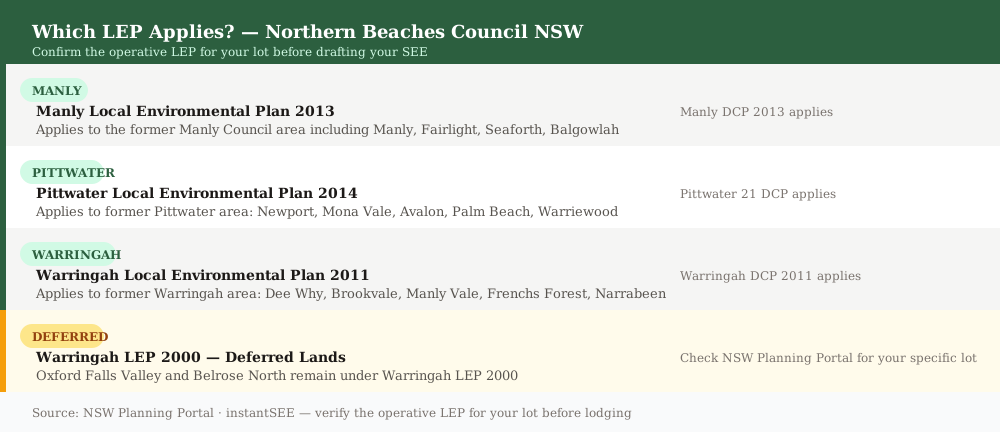 Figure 2: The four Local Environmental Plans currently in force across the Northern Beaches LGA.
Coastal Hazards and Foreshore Controls
Spend 5 minutes, not 3 weeks
instantSEE generates a complete, DA-ready Statement of Environmental Effects online. No town planner. No waiting.
Get your SEE report in 5 minutes →Northern Beaches Council's coastline is one of its defining characteristics — and one of its most significant planning constraints. Coastal erosion, inundation risk, and scenic amenity requirements run through the SEE for any foreshore or beach-adjacent DA.
Northern Beaches has an extensive coastline of ocean beaches, lagoons, and the Pittwater estuary. DAs on or near the foreshore must address:
- Coastal hazard mapping — erosion and inundation risk lines mapped by council and the NSW Government. The SEE must demonstrate how the proposal responds to identified coastal hazards and does not increase risk to life or property.
- Foreshore setbacks — minimum setbacks from the mean high water mark and from the top of the coastal escarpment, as set out in the relevant DCP.
- Scenic amenity — visual quality of the coastal landscape as seen from the beach, headlands, and public open space. Materials, colours, landscaping, and building height all contribute.
- Public access — the foreshore access corridor must not be unreasonably obstructed. The Coastal Management SEPP may impose additional requirements for development in the coastal zone.
Properties on ocean beaches from Manly to Palm Beach, and on the Pittwater estuary from Mona Vale to Church Point, are the most likely to trigger coastal hazard requirements. If your site is in the coastal zone, engage council's hazard mapping early and confirm whether a coastal hazard assessment is required as a separate supporting document to the DA.
Bushfire-Prone Land
Bushfire-prone land is one of the most widespread constraints in the Northern Beaches LGA — and one of the most consequential for your SEE. If your property adjoins a reserve or national park, the chances are it is mapped as bushfire prone.
Large parts of the Northern Beaches adjoin the Garigal National Park, Ku-ring-gai Chase National Park, and various bush reserves. Where land is mapped as bushfire prone on the Northern Beaches Council bushfire-prone land map, the following requirements apply and must be addressed in the SEE:
- Bushfire DA checklist · Confirm whether the land is mapped as bushfire prone on the council map · Determine the applicable Bushfire Attack Level (BAL) for the site · Prepare a bushfire assessment consistent with Planning for Bush Fire Protection · Demonstrate proposed asset protection zone (APZ) dimensions · Address construction standards required under the relevant BAL · Confirm Rural Fire Service concurrence requirements
Under the Environmental Planning and Assessment Act 1979, development on bushfire-prone land that requires a bushfire safety authority (including most dwelling-related DAs) must be referred to the NSW Rural Fire Service (RFS). The SEE must address the bushfire risk, demonstrate adequate APZ dimensions, and confirm that construction standards appropriate to the site's BAL are proposed.
Asset protection zones may have implications for vegetation clearing, landscaping, and fencing. These flow-on effects must also be addressed in the SEE's environmental impact assessment.
Flooding, Biodiversity, and Heritage
Beyond coastal hazards and bushfire, three further constraints commonly arise across the Northern Beaches LGA — and each adds a layer to the SEE.
Flooding and estuarine inundation affects low-lying land near creek catchments, lagoons, and the Pittwater estuary. Flood planning levels are set under the relevant DCP and by council's flood study data. The SEE must address floor levels, finished ground levels, drainage, and evacuation access where the site is flood-affected.
Biodiversity and tree canopy is a significant issue on bushland-fringe properties. Each former-council DCP sets controls for tree and vegetation retention. Where proposed clearing exceeds the threshold under the Biodiversity Conservation Act 2016, a Biodiversity Development Assessment Report (BDAR) is required. The SEE must identify whether the BDAR threshold is triggered and summarise the biodiversity assessment findings.
Heritage items and conservation areas are mapped under each former-council LEP. The Manly LEP 2013, Pittwater LEP 2014, and Warringah LEP 2011 each list heritage items in their respective schedules. A DA affecting a listed heritage item, or within a heritage conservation area, requires a heritage impact statement. The SEE must incorporate the findings of that statement.
Common DA Types in Northern Beaches
Despite the LEP complexity, the most common DA types across the Northern Beaches LGA are recognisable — and the key SEE issues for each are well-established.
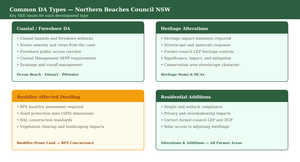 Figure 4: The four most common DA types across the Northern Beaches LGA and the key SEE issues for each.
1. Coastal and foreshore DAs Proposals on beach-facing or estuary-fronting lots must address coastal hazards, foreshore setbacks, scenic amenity, and public access. The Coastal Management SEPP may also impose specific requirements. A coastal hazard assessment is commonly required as a supporting document.
2. Heritage alterations DAs affecting heritage items or conservation areas mapped in the applicable former-council LEP require a heritage impact statement. The SEE must address the significance of the item or area, the impact of the proposed works, and the proposed mitigation.
3. Dwellings on bushfire-prone land This is the most distinctive Northern Beaches DA type. The SEE must address the bushfire risk assessment findings, APZ dimensions, BAL construction standards, and RFS concurrence requirements. This material is not optional — an SEE that omits bushfire is likely to be returned before assessment begins.
4. Residential additions Standard alterations-and-additions DAs must address height, setbacks, solar access, overshadowing, and visual and acoustic privacy under the controls of the applicable former-council LEP and DCP. The SEE must also identify the correct LEP — the most common error in Northern Beaches DAs.
Use the DA lodgement checklist to confirm what supporting documents — beyond the SEE — your Northern Beaches DA requires.
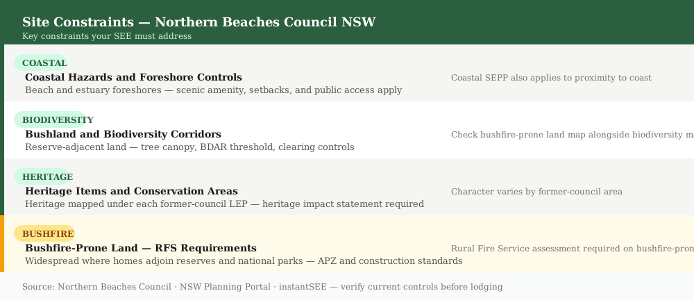 Figure 3: Key site constraints across the Northern Beaches LGA — including the amber-flagged bushfire-prone land risk.
When Does the Sydney North Planning Panel Decide?
Most Northern Beaches DAs are determined by council officers. But larger proposals go to a planning panel — and the SEE standard rises commensurately.
The Northern Beaches Local Planning Panel determines DAs that exceed council's delegation thresholds — typically applications with a capital investment value (CIV) above the relevant Minister's direction threshold, or applications that are contentious or sensitive in nature.
For regionally significant development — generally DAs with a CIV above $30 million, or proposals in the State significant development category — the Sydney North Planning Panel (SNPP) is the consent authority. Where the SNPP is the determining body, the SEE must be supported by expert reports, comprehensive environmental impact assessment, and detailed responses to each of the five matters under s 4.15(1) of the EP&A Act 1979.
If your proposal is near the SNPP threshold, seek pre-DA advice from council to confirm the determining authority before investing in the SEE preparation.
Frequently asked questions
When did Northern Beaches Council form?
Which LEP applies to a Northern Beaches DA?
Is my Northern Beaches property bushfire prone?
Can instantSEE prepare a SEE for a Northern Beaches DA?
Ready to get your SEE report?
Skip the writing. Get a DA-ready Statement of Environmental Effects in 5 minutes.
Get your SEE report