Key takeaways
- Lake Macquarie LEP 2014 and DCP 2014 govern all DA assessments
- The lake foreshore has strict building lines, setbacks and riparian buffers
- Mine subsidence over former coal workings requires Subsidence Advisory NSW approval
- Flooding around the lake and creeks sets finished floor levels
- Hunter and Central Coast Regional Planning Panel decides regionally significant DAs
A Statement of Environmental Effects (SEE) is a mandatory document for every Development Application (DA) lodged with Lake Macquarie City Council that requires consent. It demonstrates how your proposal addresses the Lake Macquarie Local Environmental Plan 2014, the Lake Macquarie Development Control Plan 2014, and the distinctive site constraints — foreshore, flooding, mine subsidence and bushfire — that shape development across this lakeside council.
Get a council-ready Statement of Environmental Effects for your DA in 5 minutes — no town planner, no waiting.
Get your SEE report →What is a Statement of Environmental Effects?
A Statement of Environmental Effects explains what your development is, how it relates to the planning framework, and how it manages its environmental impacts — it is the core document council officers read when assessing your DA.
A Statement of Environmental Effects is required under Schedule 1, Part 1 of the EP&A Regulation 2021 as part of every DA that is not exempt or complying development. It must address the matters set out in s 4.15(1) of the EP&A Act 1979 that are relevant to your proposal: the provisions of any applicable environmental planning instrument, development control plan, and any likely impacts on the natural and built environment.
For Lake Macquarie, that means your SEE must work through the Lake Macquarie Local Environmental Plan 2014 and the Lake Macquarie Development Control Plan 2014 in detail, and then address any site-specific constraints — particularly the lake foreshore, flood-affected land, mine subsidence districts, bushfire prone land, acid sulfate soils, or biodiversity areas — that apply to your site.
A thorough SEE does more than tick boxes. It shows council that you have understood the controls, that your design has responded to them, and that your proposal will not create unacceptable impacts. A thin or incomplete SEE invites requisitions that delay assessment and add cost.
 Figure 1: Key planning instruments and SEE requirements for a Lake Macquarie City Council DA.
The Lake Macquarie Local Environmental Plan 2014
The Lake Macquarie LEP 2014 is the principal statutory instrument — it sets the zone, permissibility, height, floor space ratio and other development standards for every site in the LGA.
The Lake Macquarie Local Environmental Plan 2014 (EPI 2014-0605) is a standard instrument plan made under the EP&A Act 1979. It applies across the entire Lake Macquarie local government area. The LEP:
- Zones land and determines what development is permitted with or without consent, or prohibited
- Sets maximum building height (Height of Buildings Map) and floor space ratio (Floor Space Ratio Map)
- Lists heritage items in Schedule 5 and identifies heritage conservation areas on the Heritage Map
- Identifies environmentally sensitive land, foreshore areas, flood-prone land, and other overlays
- Sets minimum lot sizes and subdivision standards
Your SEE must address zone permissibility first — is your proposed use permitted in the zone? — and then work through each relevant development standard, noting compliance or any requested variation, together with the clause 4.6 assessment if a variation is sought.
The Lake Macquarie Development Control Plan 2014
Spend 5 minutes, not 3 weeks
instantSEE generates a complete, DA-ready Statement of Environmental Effects online. No town planner. No waiting.
Get your SEE report in 5 minutes →The DCP 2014 translates LEP development standards into detailed design controls — setbacks, building heights, materials, car parking, landscaping, and foreshore and waterway provisions.
The Lake Macquarie Development Control Plan 2014 sits below the LEP and provides the detailed design and land-use controls that shape what you build and how. Key chapters relevant to most residential and mixed-use DAs include:
- Residential development — setbacks, site coverage, private open space, solar access, car parking
- Foreshore and waterway — foreshore building lines, riparian setbacks, public access strips, vegetation and water-quality requirements for land within or adjoining the lake or tidal waterways
- Flooding — finished floor levels, flood planning levels, car park and basement flood access and egress
- Environmental management — acid sulfate soils, contaminated land, tree removal
- Parking and access — rates by land use and proximity to centres
Each DCP chapter must be addressed in your SEE. Where your proposal departs from a DCP control, you need to explain why the variation is acceptable — DCP controls are not development standards subject to clause 4.6, but departures must be justified.
Lake Foreshore and Waterway Constraints
The lake foreshore is the most distinctive constraint in Lake Macquarie — foreshore building lines, riparian buffers, and water-quality controls apply to all land near the lake and tidal waterways.
Lake Macquarie is the largest coastal saltwater lagoon in Australia, and its foreshore is tightly controlled through both the LEP 2014 and the DCP 2014 foreshore and waterway chapter. For any site with frontage to or proximity to the lake, tidal creeks, or mapped waterways, your SEE must address:
- Foreshore building line — mandatory setback from the mean high water mark or mapped foreshore boundary; structures must not breach this line
- Riparian buffer — vegetated buffer between development and the waterway to protect water quality, bank stability and aquatic habitat
- Public foreshore access — where required, dedication or embellishment of a public access strip along the waterway frontage
- Water quality — stormwater management to prevent pollutants, sediment and nutrients entering the lake; often requires a stormwater management plan as a supporting document
- Visual amenity and materials — DCP controls on scale, bulk and materials visible from the lake
At Swansea, Catherine Hill Bay, Caves Beach and the open coast sections, additional State coastal framework controls apply under SEPP (Resilience and Hazards) 2021 — your SEE must address coastal hazard land provisions if your site is mapped within a coastal vulnerability area.
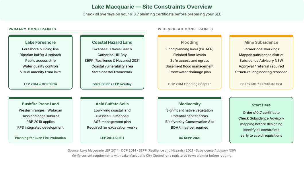 Figure 2: Key site constraints across the Lake Macquarie LGA — foreshore and coastal lead; flooding and mine subsidence apply across broad areas.
Flooding
Low-lying land around the lake and along creek systems is flood-affected — finished floor levels, drainage and safe access requirements must be addressed in every SEE for a flood-prone site.
Flooding is a widespread constraint across Lake Macquarie. Land around the lake margin, along Cockle Creek, Dora Creek, Wyee Creek and other tributaries, and in low-lying residential suburbs including Belmont, Swansea and Morisset South, falls within the flood planning area. For any flood-affected site, your SEE must address:
- Flood planning level — the finished floor level required for habitable rooms and the basis for it (council flood study, 1% AEP plus freeboard)
- Safe access and egress — whether occupants can safely enter and exit during the design flood, and what evacuation route applies
- Basement and car park flood management — flood-resilient design, and how flood waters will be managed
- Drainage — how stormwater from the site will be conveyed without increasing downstream flood impacts
Council's engineering team may require a stormwater drainage plan or, for larger or complex sites, a flood impact assessment prepared by a hydraulic engineer.
Mine Subsidence
Much of the Lake Macquarie LGA sits over former underground coal workings — mine subsidence is a distinctive local constraint that can require Subsidence Advisory NSW approval before your DA proceeds.
The Lake Macquarie area was the heartland of the Hunter coalfield, and former underground coal mining has left mapped mine subsidence districts beneath suburbs including parts of Belmont, Windale, Glendale, and the western and northern areas of the LGA. If your site falls within a mine subsidence district:
- Subsidence Advisory NSW may need to approve your development, or provide advice to council, before a DA can be determined
- Your SEE must note that the site is mine-affected and identify the relevant approval pathway
- Structural engineering may need to address subsidence risk in design
Check your section 10.7 planning certificate and the Subsidence Advisory NSW mapping tool before lodging — identifying this constraint early prevents a requisition mid-assessment.
Other Site Constraints
Bushfire prone land, acid sulfate soils and biodiversity overlays apply across parts of the LGA — check all overlays on your planning certificate before preparing your SEE.
Beyond the foreshore, flooding and mine subsidence, several other constraints apply across the Lake Macquarie LGA:
- Bushfire prone land — the bushland edge and western ranges (Watagan ranges, Morisset areas) are mapped as bushfire prone. Development in these areas must comply with Planning for Bush Fire Protection 2019 (PBP 2019), and if the development is integrated development, an approval from the NSW Rural Fire Service is required
- Acid sulfate soils — low-lying coastal land may contain acid sulfate soils. If excavation or drainage works are proposed within mapped ASS land, an acid sulfate soils management plan is required
- Biodiversity — parts of the LGA contain significant native vegetation and potential habitat. The Biodiversity Conservation Act 2016 and the Biodiversity Conservation SEPP apply — a Biodiversity Development Assessment Report (BDAR) may be required if the development exceeds the relevant thresholds
Your SEE should note each applicable constraint, address relevant controls, and identify any specialist reports required as supporting documents.
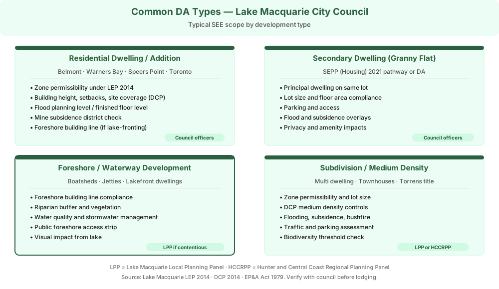 Figure 3: Common DA types lodged with Lake Macquarie City Council and their typical SEE scope.
Who Decides a Lake Macquarie DA?
Decision-making in Lake Macquarie follows a tiered pathway — most DAs are determined by council officers, with larger or contentious applications going to the Local Planning Panel or the Regional Planning Panel.
The decision-maker for a Lake Macquarie DA depends on the scale and nature of the development:
- Council officers (delegation) — most standard residential DAs, secondary dwellings, alterations and additions, and smaller commercial applications
- Lake Macquarie Local Planning Panel — DAs that are contentious, above certain thresholds, involve a council interest, or are in sensitive locations; the Panel is an independent merit-review body
- Hunter and Central Coast Regional Planning Panel — regionally significant development above the applicable capital investment value threshold, and certain other categories of development specified in the regulations
Your SEE is the foundational document whichever pathway applies — the Panel or Regional Planning Panel will refer to it closely for more complex applications.
- Lake Macquarie foreshore or flood DA · Lake foreshore building line and riparian setback · Finished floor levels (flood planning area) · Mine subsidence district check (Subsidence Advisory NSW) · Bushfire prone land at bushland edge · Coastal hazard land at Swansea and Catherine Hill Bay
How to Lodge a Lake Macquarie DA
All Lake Macquarie DAs are lodged online through the NSW Planning Portal — you upload your SEE, plans and supporting documents, pay the fee, and council registers and assesses your application.
Lake Macquarie City Council accepts all DA lodgements through the NSW Planning Portal at planningportal.nsw.gov.au. To lodge:
- Create or log in to your NSW Planning Portal account
- Start a new development application and select Lake Macquarie City Council
- Enter the site address and describe the proposed development
- Upload your plans, Statement of Environmental Effects, owner's consent, and all required supporting documents (flood report, subsidence letter, stormwater plan, etc.)
- Pay the lodgement fee (calculated on the estimated cost of development)
- Submit — council registers the application, assigns an assessment officer, and notifies neighbours where required
Council then assesses the DA under s 4.15(1) of the EP&A Act 1979, considering all matters of relevance including your SEE, the LEP, the DCP, agency referrals, and any public submissions.
Frequently asked questions
Do I need a Statement of Environmental Effects for a Lake Macquarie DA?
Which LEP applies to a Lake Macquarie development application?
Is my Lake Macquarie property affected by mine subsidence?
How do I lodge a DA with Lake Macquarie Council?
Ready to get your SEE report?
Skip the writing. Get a DA-ready Statement of Environmental Effects in 5 minutes.
Get your SEE report