Key takeaways
- Canada Bay LEP 2013 aims to protect Parramatta River foreshore access
- Foreshore building lines and public access apply to waterfront sites
- Flooding affects Powells Creek, Exile Bay, Concord West, Rhodes East
- Acid sulfate soils are mapped for low-lying riverfront land
- Sydney Eastern City Planning Panel determines larger Canada Bay DAs
A Statement of Environmental Effects (SEE) is the primary planning document you must lodge with every standard development application (DA) in the City of Canada Bay. It must satisfy the content requirements set out in Schedule 1, Part 1 of the EP&A Regulation 2021, and it must demonstrate how your proposal responds to the Canada Bay Local Environmental Plan 2013 and the City of Canada Bay Development Control Plan. For waterfront properties, foreshore access, building lines, and visual amenity are at the front of any assessment. Flooding affects four named catchment areas. Heritage and acid sulfate soils add further layers of assessment that must be addressed in your SEE before the council will accept a DA as lodged.
Get a council-ready Statement of Environmental Effects for your DA in 5 minutes — no town planner, no waiting.
Get your SEE report →What Planning Instruments Govern Canada Bay DAs?
Every Canada Bay DA is assessed against a layered stack of planning instruments. Understanding the hierarchy before you write your SEE saves time and avoids requisitions.
The City of Canada Bay sits within inner-western Sydney, bounded by the Parramatta River to the north and east. Its suburbs include Concord, Concord West, Drummoyne, Five Dock, Rhodes, Cabarita, Mortlake, and Abbotsford. The planning framework that applies to development across this municipality operates at three levels.
Canada Bay Local Environmental Plan 2013. The LEP 2013 is a standard instrument plan made under the Environmental Planning and Assessment Act 1979. It was gazetted on 19 July 2013 and applies across the entire City of Canada Bay local government area. One of its stated aims is to facilitate public access to foreshore land along the Parramatta River. The LEP 2013 controls permissibility, height, floor space ratio, heritage, foreshore building lines, and mapped overlays including acid sulfate soils and flood-prone land.
City of Canada Bay Development Control Plan. The DCP provides detailed controls that apply beneath the LEP 2013. It sets out heritage design guidelines, foreshore design standards, residential character controls, and flood provisions. Your SEE must demonstrate compliance with relevant DCP chapters.
Schedule 1, Part 1 of the EP&A Regulation 2021. This is the legal minimum content floor for every SEE lodged in New South Wales. It requires the document to describe the proposal, address environmental impacts, and explain how the proposal responds to the relevant planning instruments. Compliance with this Schedule is a mandatory condition of a valid DA.
s 4.15(1) of the EP&A Act 1979. The council assesses your DA against the five-part framework in s 4.15(1): the provisions of any applicable environmental planning instrument (including the LEP 2013 and any SEPPs), the DCP, the likely impacts on the natural and built environments, the suitability of the site, and the public interest.
State Environmental Planning Policies. Coastal, biodiversity, and housing SEPPs may apply depending on site location and proposal type. Verify which SEPPs are relevant for each lot before lodging.
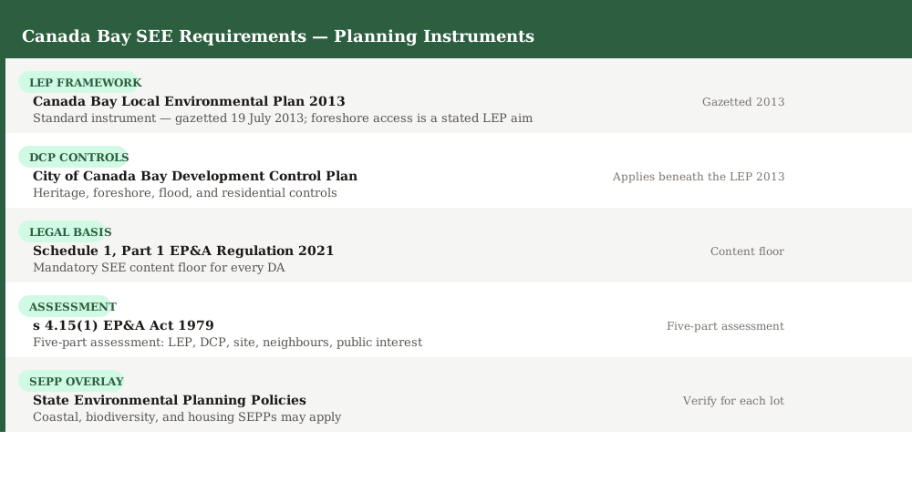 Figure 1: The five planning instruments and frameworks that govern an SEE for a Canada Bay Council DA.
Parramatta River Foreshore — Building Lines and Public Access
The Parramatta River foreshore is the defining landscape feature of the City of Canada Bay. The LEP 2013 treats public access to that foreshore as a primary planning objective — and your SEE must engage with it directly for any waterfront or near-foreshore site.
The Canada Bay LEP 2013 contains a stated aim to facilitate public access to foreshore land. For sites near the Parramatta River, this translates into concrete controls: foreshore building lines, which restrict how close structures can be placed to the water; and provisions that protect public views, scenic quality, and physical access along the foreshore corridor.
Foreshore building lines are mapped in the LEP 2013. Development within a foreshore building line requires separate consent consideration, and your SEE must explain why the proposal is consistent with foreshore access and scenic quality objectives.
Public access and views. The LEP and DCP require SEEs to address whether a proposed development impedes public access to or along the foreshore, and whether it would harm views from publicly accessible locations to the water or across the Parramatta River.
Rhodes high-density precinct. Rhodes sits at the eastern tip of the LGA where the Parramatta River meets Homebush Bay. Development in this high-density precinct raises foreshore access, density, built form, and amenity considerations that your SEE must address in detail.
Scenic quality and landscape character. For elevated or visually prominent sites, the SEE should include a view impact analysis demonstrating that the proposed works do not harm the scenic quality of the foreshore corridor.
- Foreshore SEE items · Foreshore building line compliance · Public access to and along the foreshore · Views and scenic quality · Visual amenity and landscape character · Rhodes precinct built form if relevant
Flooding — Powells Creek, Exile Bay, and the Catchment Studies
Spend 5 minutes, not 3 weeks
instantSEE generates a complete, DA-ready Statement of Environmental Effects online. No town planner. No waiting.
Get your SEE report in 5 minutes →Flooding is one of the most significant site constraints across the City of Canada Bay. The council holds flood studies across four named catchments, and if your land falls within a flood-prone area, your SEE must address it — or the DA will not proceed.
The City of Canada Bay has commissioned flood studies across the following catchments: Powells Creek, Exile Bay, Concord West, and Rhodes East. If your site falls within any of these catchment areas, flood planning controls apply and your SEE must address them.
What flood planning controls apply? Where land is identified as flood-prone, the LEP 2013 and DCP impose controls including: minimum finished floor levels; requirements to address the 1% Annual Exceedance Probability (1% AEP) flood event; consideration of the Probable Maximum Flood (PMF); and evacuation and overland flow path considerations.
Where flood information is unknown. The council may require a qualified hydraulic engineer to assess flood risk where flood data is unavailable or where the site is on the fringe of a mapped flood area. If your SEE does not address flooding and your site is near a mapped catchment, expect a requisition.
What your SEE must include. For flood-affected sites: a description of the flood planning level and how the proposed finished floor levels respond to it; an assessment of overland flow paths; and where required, a flood report from a qualified engineer.
Amber hazard — Flooding. Powells Creek, Exile Bay, Concord West, and Rhodes East are all subject to council flood studies. If your site is flood-affected, the SEE must address finished floor levels, the 1% AEP flood event, and PMF. Where flood information is unknown, the council may require a qualified engineer's assessment before the DA proceeds.
Heritage, Acid Sulfate Soils, and Tree Canopy
Three further constraints — heritage, acid sulfate soils, and tree canopy — are mapped in the Canada Bay LEP 2013 and DCP. Each requires specific SEE content.
Heritage items and heritage conservation areas. The Canada Bay LEP 2013 maps heritage items and heritage conservation areas (HCAs) across the LGA, including in Concord, Drummoyne, and Five Dock. If your site contains or adjoins a heritage item, or is within a heritage conservation area, your DA must be accompanied by a heritage impact statement that is separate from but referenced in the SEE. The SEE must summarise the heritage context and explain how the proposal respects the heritage significance of the item or area.
Acid sulfate soils. Acid sulfate soils are mapped in the Canada Bay LEP 2013 for low-lying land near the Parramatta River. Excavation in acid sulfate soil areas can release sulfuric acid into waterways, causing significant environmental damage. If your site is within a mapped acid sulfate soil area, your SEE must address the risk. An acid sulfate soil management plan may be required before any excavation below the water table. Check the LEP 2013 acid sulfate soils map for your lot.
Tree canopy and tree controls. The City of Canada Bay DCP contains tree preservation and planting controls. Removal of or impact on significant trees requires separate assessment. Your SEE should identify any trees on or adjacent to the site and explain how the proposal responds to tree canopy controls.
- Heritage and environmental SEE items · Heritage item or HCA status · Heritage impact statement reference · Acid sulfate soil map check · Acid sulfate soil management plan if required · Tree canopy impact assessment
Common DA Types in Canada Bay
Most DAs in Canada Bay fall into one of four categories. Each type has a distinct SEE focus area.
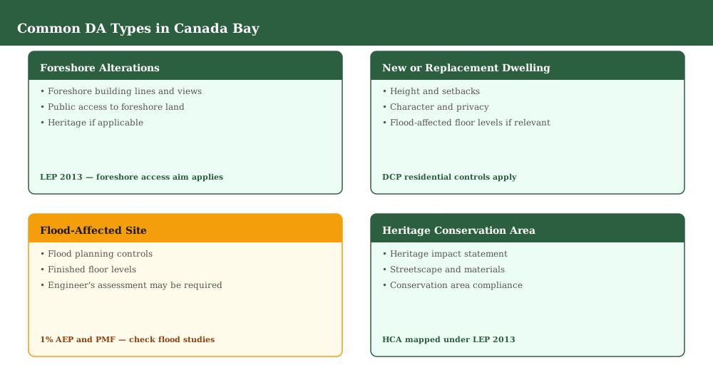 Figure 3: The four common DA types in Canada Bay and the key SEE topics each one requires.
Foreshore alterations. Works near the Parramatta River must address foreshore building lines, public access, views, scenic quality, and heritage where applicable. The LEP 2013 foreshore access aim must be engaged in the SEE.
New or replacement dwellings. For residential proposals across the LGA — including knockdown-rebuilds and substantial alterations — the SEE must address height, setbacks, privacy, solar access, and character, and must account for any flood, heritage, or acid sulfate soil overlays affecting the site.
Flood-affected sites. Where the site falls within a Powells Creek, Exile Bay, Concord West, or Rhodes East catchment flood study area, the SEE must address flood planning controls, finished floor levels, and engineer's assessment requirements.
Heritage conservation areas. Works within or adjacent to a heritage conservation area must be supported by a heritage impact statement. The SEE must address streetscape character, materials, and conservation area compliance.
For a full DA lodgement checklist applicable across NSW, see the DA lodgement checklist.
When Does the Sydney Eastern City Planning Panel Decide?
Not all Canada Bay DAs are determined by council officers. Above certain cost-of-works thresholds, the Sydney Eastern City Planning Panel takes over as consent authority.
The City of Canada Bay falls within the jurisdiction of the Sydney Eastern City Planning Panel (SECPP). The SECPP determines DAs where the capital investment value (CIV) exceeds the threshold set by the Minister for Planning (generally $30 million or above, or where the DA is of a class prescribed by planning directions). Regionally significant development is also referred to the SECPP.
For DAs below that threshold, applications are determined by council officers for straightforward proposals, or referred to the Canada Bay Local Planning Panel where proposals involve: a matter of public interest; a heritage item; contentious neighbour notification; or a planning agreement.
The SEE content requirements are the same regardless of which body determines the DA. However, SEEs for Panel-referred applications are subject to greater public scrutiny and should be particularly thorough in their treatment of environmental impacts.
Frequently asked questions
When did the Canada Bay LEP 2013 come into force?
Is my Canada Bay property flood affected?
What is the acid sulfate soil risk in Canada Bay?
Can instantSEE prepare a SEE for a Canada Bay DA?
Ready to get your SEE report?
Skip the writing. Get a DA-ready Statement of Environmental Effects in 5 minutes.
Get your SEE report