Key takeaways
- Every Georges River DA requiring consent needs a Statement of Environmental Effects
- The Georges River LEP 2021 replaced both the former Hurstville and Kogarah LEPs
- Foreshore, flooding and strategic centres are key Georges River SEE issues
- Section 4.15 sets five mandatory matters for every DA assessment
- Most residential Georges River DAs are decided by a council officer
A Statement of Environmental Effects for a Georges River Development Application must show how your proposal sits with the Georges River Local Environmental Plan 2021 and the Georges River Development Control Plan, and how it manages its impacts on neighbours and the surrounding area. Every DA lodged with Georges River Council that needs consent must include one.
Georges River was formed in 2016 from the merger of Hurstville and Kogarah councils, and the rulebook only settled when the Georges River Local Environmental Plan 2021 came into effect on 8 October 2021. That single plan now applies across the whole local government area, so older guides and templates that quote the former Hurstville LEP 2012 or Kogarah LEP 2012 can cite standards that no longer apply. The area runs down to the Georges River foreshore, parts of it flood from the river and Salt Pan Creek, and the Hurstville and Kogarah centres are strategic centres marked for growth.
This guide explains what a Georges River SEE has to cover, the constraints that shape it, the common DA types in the area, how to lodge with the council, and whether you need a town planner.
Get a council-ready Statement of Environmental Effects for your DA in 5 minutes — no town planner, no waiting.
Get your SEE report →- What Georges River Council requires in a Statement of Environmental Effects
- How the foreshore, flooding and strategic centres shape your Georges River SEE
- Common DA types in Georges River and what each SEE must address
- How to lodge a Georges River DA through the NSW Planning Portal
- Who determines your application — officer, Georges River LPP, or State panel
What Georges River Council Requires in a SEE
Your SEE must address five matters under section 4.15 — LEP compliance, DCP compliance, site constraints, neighbour impacts, and the public interest — with the foreshore, flooding, and strategic centre density each potentially decisive depending on your location.
Your Statement of Environmental Effects for a Georges River DA must address five things: how your proposal complies with the Georges River LEP 2021, how it meets the Georges River DCP, the constraints on your specific site, the impacts on your neighbours, and the public interest. These map directly onto the matters a council must weigh under section 4.15 of the Environmental Planning and Assessment Act 1979.
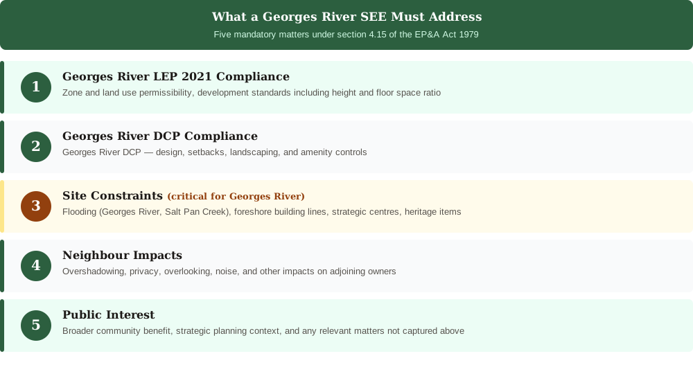
Figure 1: The five matters a Georges River SEE must address. They mirror the section 4.15 assessment the council runs.
Georges River Council's principal planning instruments are the Georges River Local Environmental Plan 2021 and the Georges River Development Control Plan. The LEP 2021 is a standard instrument plan made under the EP&A Act 1979, and it replaced the former Hurstville and Kogarah LEPs, so make sure any standard you rely on comes from the current plan.. Maximum building height, FSR, and setback standards for your zone are set by the Georges River LEP 2021 and Georges River DCP — confirm the applicable figures for your lot on the NSW ePlanning Spatial Viewer or your section 10.7 certificate. Confirm the DCP's current title on the council's planning controls page.
The Foreshore, Flood, and Centre Constraints Your Georges River SEE Must Address
Georges River's combination of a consolidated LEP 2021, two strategic centres at Hurstville and Kogarah, a riverside foreshore with scenic protection, and flood-prone land near the river and Salt Pan Creek means the site constraints section of your SEE does substantial work.
The constraints in Georges River are the constraints of a riverside, partly low-lying inner-south, and your SEE has to confront the ones that touch your land.
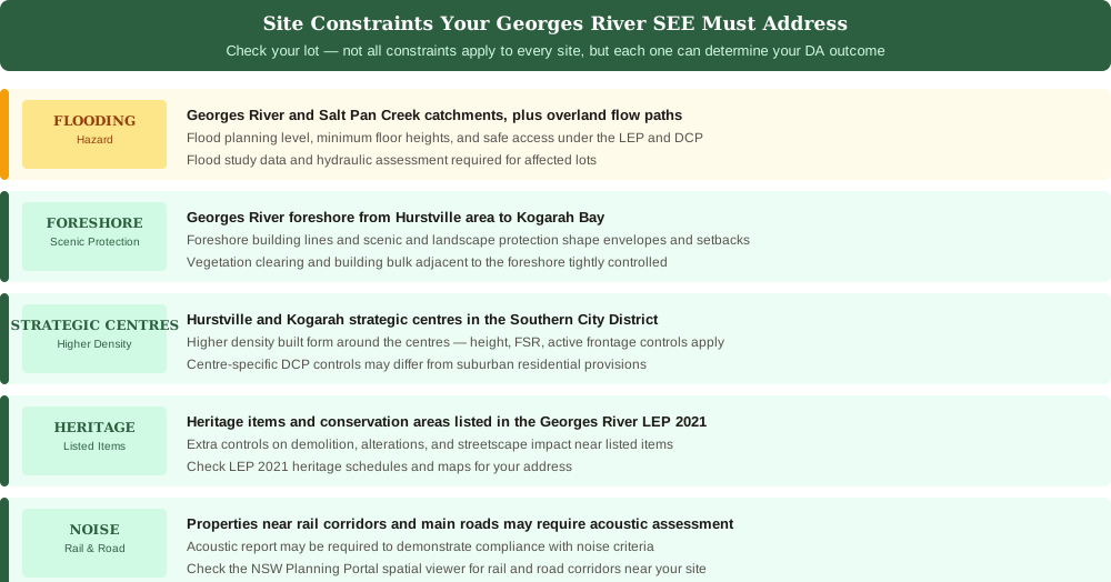
Figure 2: The constraints that shape a Georges River SEE. Flooding is flagged as a hazard.
The Hurstville and Kogarah centres are strategic centres in the Southern City District, with higher density planned around them, so built form and density are central near those centres. Land along the Georges River foreshore is subject to foreshore building lines and scenic and landscape protection, which shape building envelopes, setbacks, and vegetation. Flooding affects land near the Georges River and Salt Pan Creek, along with overland flow paths in built-up areas, with controls set in the LEP and DCP and triggered by the council's flood studies. Heritage items and conservation areas are listed in the LEP 2021, and development on or near them faces extra controls on demolition, alterations, and streetscape. Homes near rail corridors and main roads may need noise and vibration design.
Common DA Types in Georges River and What Your SEE Must Address
Spend 5 minutes, not 3 weeks
instantSEE generates a complete, DA-ready Statement of Environmental Effects online. No town planner. No waiting.
Get your SEE report in 5 minutes →The focus of your SEE shifts with the project type and the constraints on your lot — foreshore sites need scenic protection and building envelope addressed upfront, while a standard addition on unconstrained residential land centres on overshadowing and privacy.
Most residential DAs lodged with Georges River Council fall into a handful of types, and the focus of your SEE shifts with each one.
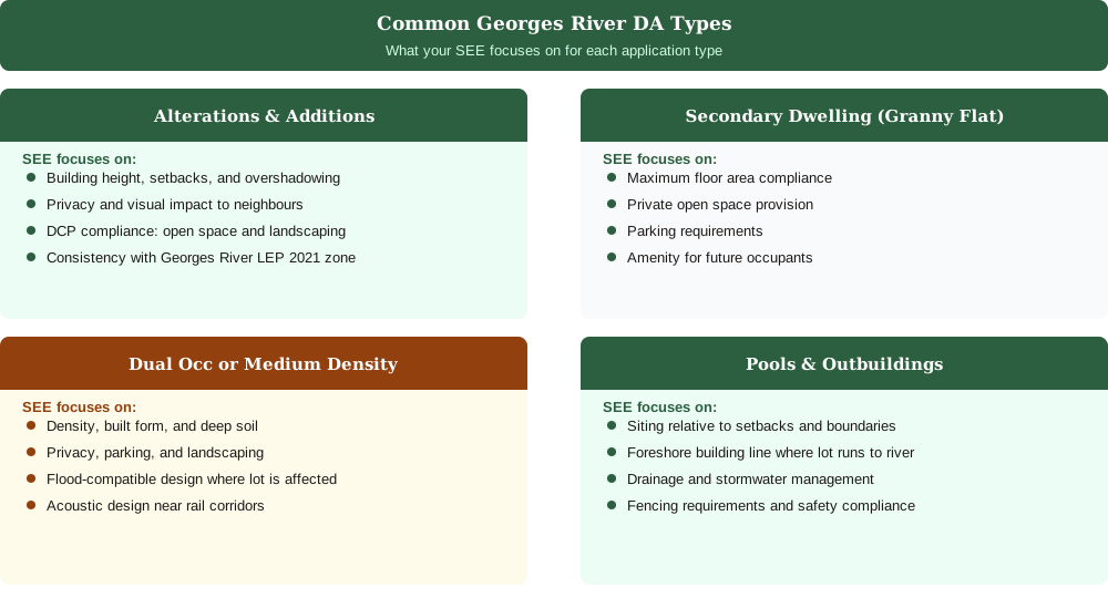
Figure 3: The four most common Georges River DA types and where each SEE puts its weight.
For alterations and additions, your SEE concentrates on height, setbacks, overshadowing, and privacy to neighbours. For a secondary dwelling, often called a granny flat, the focus is floor area, private open space, parking, and amenity. For a dual occupancy or medium-density development, it addresses density, built form, deep soil and landscaping, privacy, and parking. For pools and outbuildings, it covers siting, drainage, fencing, and the streetscape, plus the foreshore building line where the lot runs to the river. A DA lodgement checklist for NSW helps you gather the right supporting documents for each.
- Confirm consent is required by checking your LEP 2021 zone and land use table
- Prepare plans, SEE, owner's consent, and BASIX certificate where needed
- Lodge on the NSW Planning Portal and pay the DA lodgement fee
- Respond promptly to any council requests for additional information
- Await council assessment against section 4.15 and the determination
How to Lodge a DA with Georges River Council
You lodge every Georges River DA through the NSW Planning Portal — upload plans, SEE, owner's consent, and pay the fee; the council registers it, notifies neighbours, and assesses it against section 4.15.
You lodge a Georges River DA through the NSW Planning Portal at planningportal.nsw.gov.au, the system every NSW council uses, and the council confirms all DAs must be lodged online there. You upload your plans, owner's consent, supporting documents, and your SEE, then pay the fee. Our step-by-step guide to lodging a DA in NSW covers the portal mechanics.
Once lodged, the council registers your DA, notifies adjoining owners where required, and assesses it against section 4.15. Most straightforward residential DAs are decided by a council officer under delegated authority. More contentious or significant applications go to the Georges River Local Planning Panel, and regionally significant development is determined by the Sydney South Planning Panel. The general DA requirements across NSW councils follow the same legislative base, so a complete Georges River lodgement looks much like any other once you are working from the right plan.
Do You Need a Town Planner for a Georges River DA?
For a straightforward residential DA on unconstrained land you can prepare the SEE yourself — but foreshore sites, flood-affected lots, and strategic centre proposals are where a specialist earns their fee.
Not always. For a straightforward residential DA on an unconstrained lot, such as a single-storey addition, a granny flat, or a pool, you can prepare the SEE yourself or use a service rather than engaging a town planner. A traditional town planner in NSW typically charges $800 to $2,500 and takes one to three weeks, which is a lot for a clearly compliant project.
You are more likely to want a planner where the project is complex: a higher-density site near the Hurstville or Kogarah centre, a foreshore lot with scenic protection controls, a flood-affected site near the river or Salt Pan Creek, a heritage item or conservation area, or a proposal that seeks to vary a development standard such as height under clause 4.6. For the common residential cases, a well-structured SEE that addresses the current Georges River LEP 2021 and DCP is what you need.
Frequently asked questions
Do I need a Statement of Environmental Effects for a Georges River DA?
Which LEP applies to a Georges River development application?
How do I lodge a DA with Georges River Council?
Is my Georges River property affected by the foreshore or flooding?
Ready to get your SEE report?
Skip the writing. Get a DA-ready Statement of Environmental Effects in 5 minutes.
Get your SEE report